When German coastal researchers head for the North Sea this May to measure the nutrient load in the water and, for the first time, whenever they use a scientific instrument, it is automatically recorded by an app, above all they’ll have the ingenuity of AWI sea-ice engineer Martin Schiller to thank for the new service. After taking part in a several-hour-long search operation in the Arctic, he developed FloeNavi, a system for navigating and locating measuring sites on sea ice. The AWI Computing Centre has since expanded the system’s most popular function, the metadata generator, into a separate app. The AWI’s Data Managers will now make it available to all members of the German Marine Research Alliance – the goal being to make scientific data more transparent and easier to verify.
When human beings reach the limits of what they can do naturally, they have to get creative. Working from this basic premise, Martin Schiller chose to pursue a career with a heavy focus on IT, and it was also an idea that, after the AWI sea-ice engineer was involved in a several-hour-long search operation on the sea ice of the Central Arctic in October 2016, wouldn’t let him go. “We had deployed measuring instruments that cost the equivalent of several passenger cars on the sea ice, and now, a year later, we returned to retrieve them. But when our ship moored at the floe in question, we found the entire surface covered with thick snow and riddled with several-metre-high pressure ridges. As a result, we didn’t have the faintest idea where on the massive floe our instruments could be,” Schiller recalls.
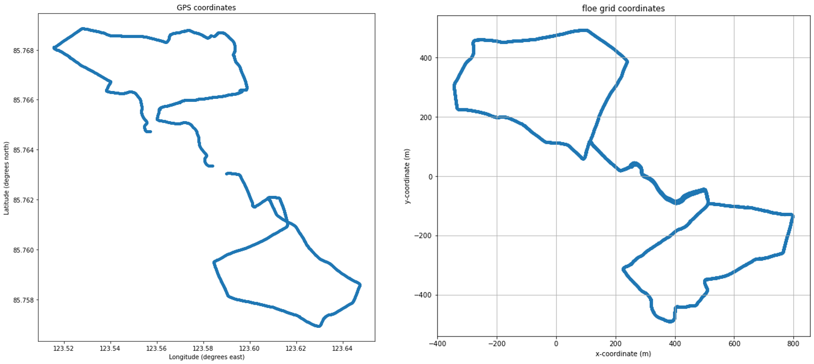
The GPS coordinates recorded a year earlier were of little help to the AWI sea-ice experts: “On land, when you set up a measuring site, you can record its GPS coordinates, allowing you to find it again whenever you need to. But on the sea ice, the problem is that the floes move. We can determine a given site’s GPS position, but it only refers to the ocean floor and can’t take into account what direction the floe has drifted in, or how many degrees it has rotated,” says Schiller.
Back at his AWI office in Bremerhaven, he began working with sea-ice physicist Dr Marcel Nicolaus to find a technological solution for this drift-ice-specific research problem. And the clock was ticking: the Arctic expedition MOSAiC, during which the AWI’s sea-ice team was to spend an entire year working on the surface of a drifting ice floe, was slated to launch just three years later. “The search operation in the Arctic made us realise that, for the MOSAiC expedition, we would need a system that could help us find our monitoring stations on the ice, day or night. Our researchers were also on the lookout for a way to automatically record the coordinates and times when measurements were taken or samples were gathered, which would make it possible to determine at any time where, when and with what instrument the data or samples were collected,” the electrical engineer explains.
The answer: positioning technology normally used in shipping
In terms of the theory, the solution was quickly found: essentially, all Martin Schiller had to do was project a two-dimensional coordinate system on the floe, one that would move with the ice. Then the X- and Y-axes could be used to precisely record all relevant sites on the floe, so that the researchers could always find them again – e.g. for weekly ice-thickness and snow-thickness readings. But how could he implement the basic idea? The hobby sailor opted for positioning and communications technologies normally used on ships.
To avoid accidents and collisions in international shipping, all vessels are equipped with the automatic identification system AIS. It constantly transmits each ship’s coordinates, course, speed and other basic data on FM radio, so that other nearby ships know of its presence and can plan or adjust their courses accordingly. “As a research icebreaker, Polarstern naturally had her own AIS transmitter and receiver, which gave me the idea of basing the coordinate system for the floe on AIS transmitters,” Schiller relates.
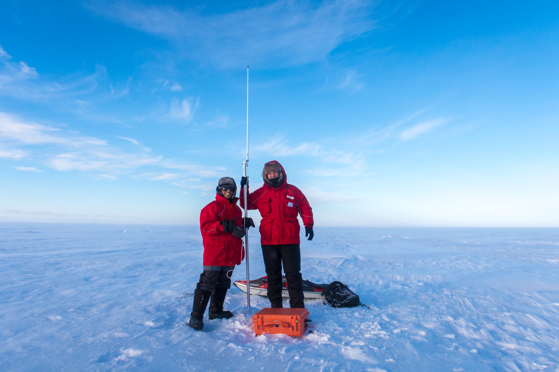
His plan: to deploy a first transmitter, safely stowed away in its own container, on the ice, where it would serve as the origin (zero-point) for the coordinate system; then he would install a second at a predefined distance, to mark the direction of the X-axis. Both transmitters would broadcast their positioning data nonstop. Then the projection of the Y-axis, and with it, the structure of the remaining coordinate grid, would be provided by a piece of software, which would process the positioning data constantly broadcast by the two AIS base stations on the ice and calculate the exact position of the coordinate system. But that wasn’t all!
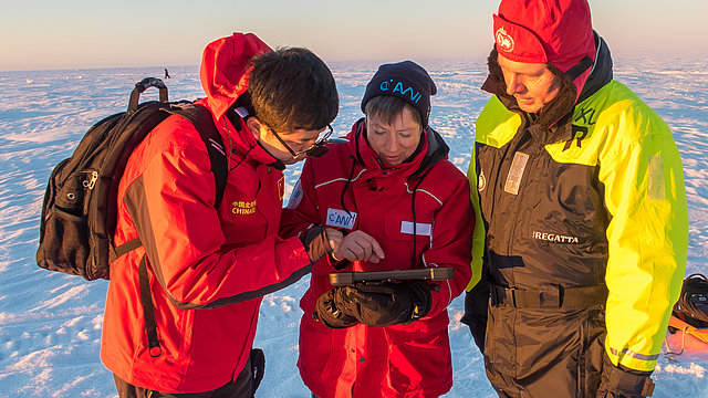
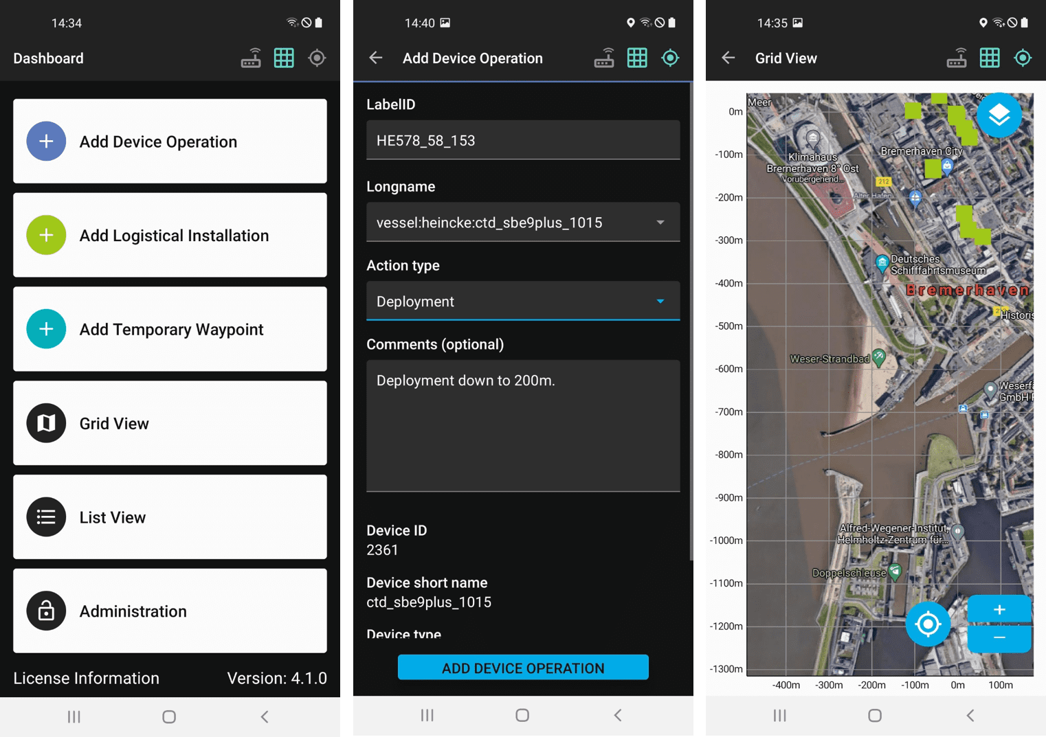
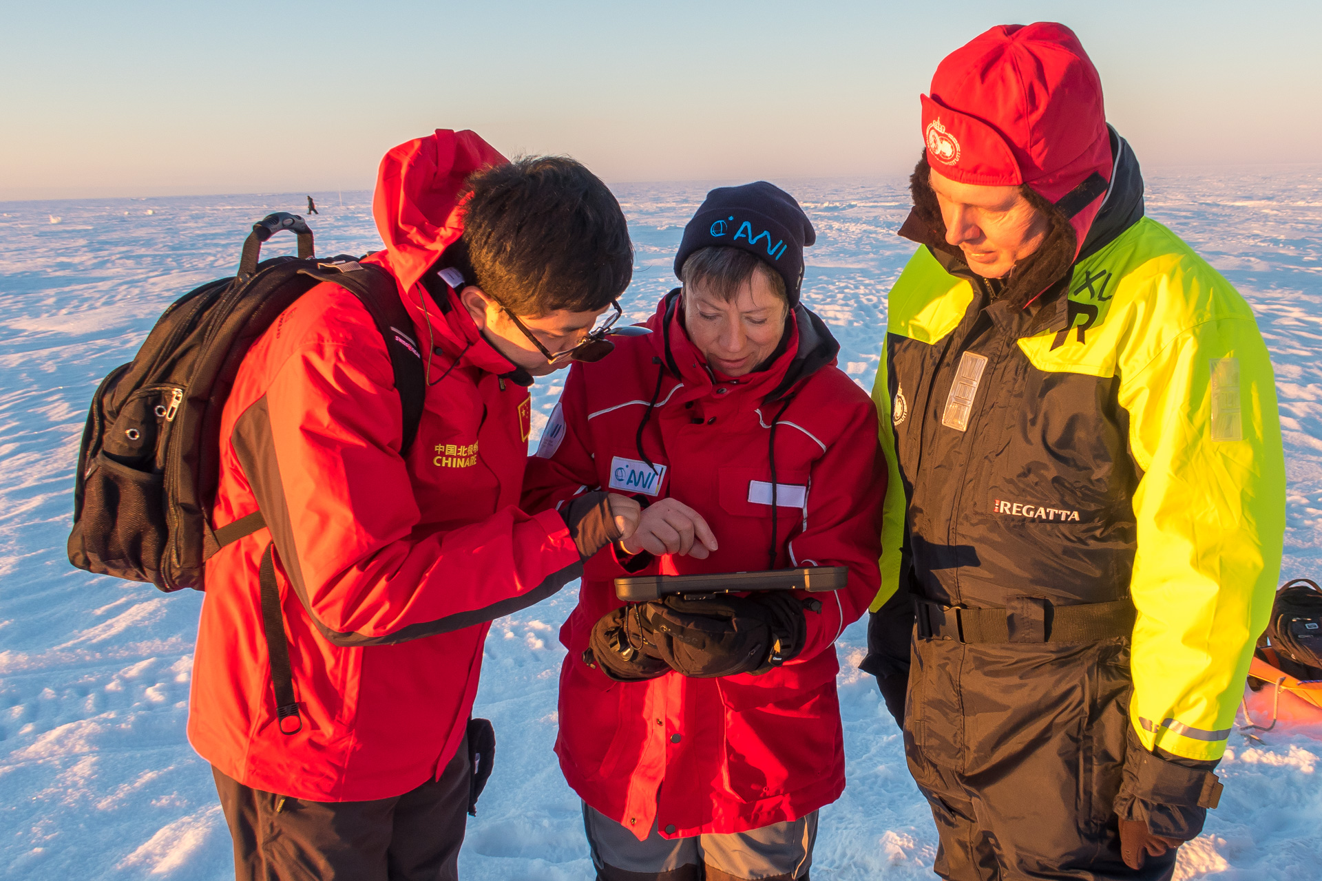
In order to mark the positions of individual stations or the course of certain measuring routes in this coordinate system, Martin Schiller developed a small AIS box that every researcher could take with them on the ice using a sledge. The box contains both an AIS receiver that processes the positioning data from the two base stations, and a Wi-Fi hotspot that allows the AIS data to be transferred from the box to a corresponding tablet. In turn, a specially designed piece of software installed on the tablet was to show researchers their exact position on the floe using the AIS coordinate system and give them the option of saving their current position at any time with just a click. Drawing on English nomenclature, Martin Schiller dubbed the new program the FloeNavi app.
In addition, the app would display a selection of equipment and activities to the researchers, allowing them to digitally document it whenever they collected ice cores, piloted ROV dives, sent up weather balloons or measured the temperature of the snow. In the next step, all of the positioning, timestamp, device and activity data gathered on the floe was to be automatically transferred from the Research Vessel Polarstern to the data network for German research ships (D-Ship) and archived there.
Field testing in the Central Arctic
The concept was sound, and the AIS base stations and boxes for the researchers were quickly completed. Nadem Gul and Rintu Daniel, two Master’s students at Bremerhaven University of Applied Sciences, programmed the FloeNavi app version 1.0, while experts at the AWI Computing Centre prepared the data integration into the D-Ship system. The only aspect that proved difficult: testing the new FloeNavi system far from the Arctic. “We tried everything, including setting up our system on the Weser River ferry. We then travelled back and forth on the ferry, and pretended the ferry was our ice floe,” Schiller relates.
Yet the ferry trips across the Weser were a poor substitute for the much slower drifting of Arctic sea ice, as was the MOSAiC preparatory training in Finland, which took place on ‘fast ice’ – sea ice that had frozen onto the coast and didn’t budge an inch.
“Later, when we moored Polarstern at the MOSAiC floe and set up the system on the sea ice for the first time, we discovered that the positioning calculation wasn’t precise enough, and that there were tiny flaws in the software,” recalls Schiller, who immediately got in touch with his colleagues at the AWI Computing Centre; they then jointly decided to have the FloeNavi-App reworked as soon as possible. The job was awarded to the company Zühlke Engineering.
At the same time, all MOSAiC participants used the AIS boxes and tablets as instructed to record their measurements and other activities on the ice, including the positioning and timestamp. “We were able to use the FloeNavi system from the outset to record it whenever we used instruments on the floe, instead of – like we used to – typing it into our personal field logs back on board so that we had a digital record,” says AWI sea-ice expert Dr Marcel Nicolaus.
What’s more, throughout the expedition, the FloeNavi system succeeded in precisely recording the floe’s rotation and other movements. “This information will now be used, for instance, to correctly determine the coordinates of our survey flights over the floe and profile measurements on its surface,” the sea-ice physicist explains.
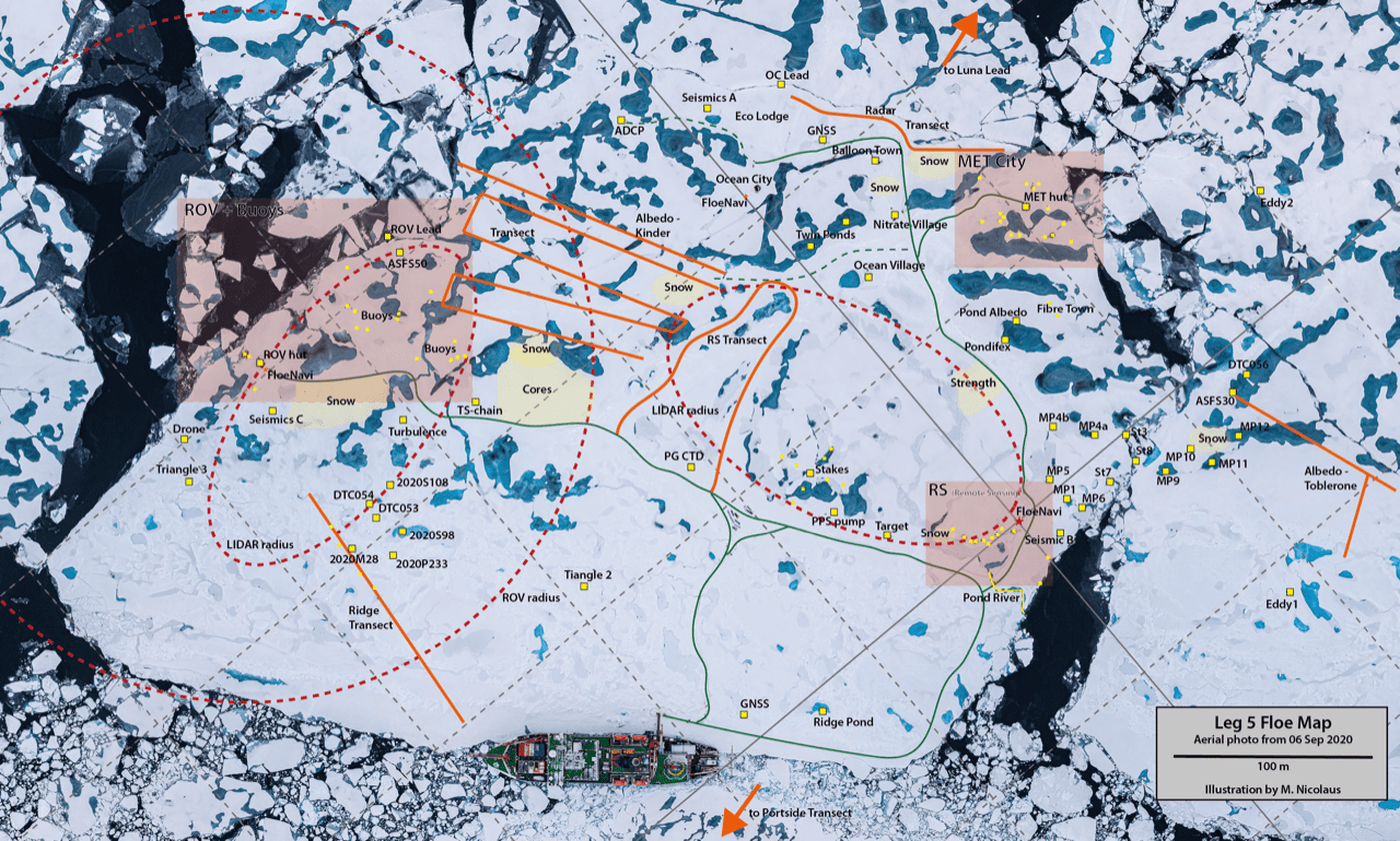
Marcel Nicolaus personally took part in both the first and fifth legs of MOSAiC, and during the latter had the opportunity to try out the revised version of the FloeNavi app (2.0) on the floe. “Among other things, I was responsible for creating a map of the floe, and walked to every instrument installed on the ice, taking an AIS box and tablet with me. Whenever I came to the next one on the list, I selected the appropriate instrument from the app menu, clicked on it and added the positioning data, so that, in the end, we were able to create a highly detailed map, and can now precisely determine where on the drifting flow each instrument was, at any given time.”
A single app for all types of field research
When the Data Managers at the AWI Computing Centre shared the news about this simple, and above all standardised, method for recording metadata on the MOSAiC ice floe with the German Marine Research Alliance (DAM), the listeners pricked up their ears. An app like this could be used not just for ship-based expeditions in the Central Arctic, but for all types of field research, especially if it could also generate metadata when offline.
“On the large German research vessels, all the scientific work is recording using the D-Ship system. However, for smaller coastal vessels and land-based expeditions, until now there hasn’t been a similar, uniform technical solution. Instead, each research group used its own documentation method, which, in the end, made processing the data more difficult and time-consuming,” says Norbert Anselm, a Data Manager at the AWI Computing Centre.
Accordingly, the AWI Computing Centre’s Data Logistics Support Team decided to pursue the further development of the FloeNavi app’s metadata generator, so that it could be used for any type of field research, even in offline mode, and on tablets and smartphones alike. According to Anselm: “The app has retained all its key functions, but can now also be used independently of an AIS coordinate system.”
The logic behind the new app is simple: in land-based expeditions and those in ice-free ocean regions, there’s no need to worry about drift. That means that GPS coordinates alone are enough to accurately locate measurements. The name of the new, universally applicable metadata generator: the ‘Mobile ActionLog app’.
Now, when researchers document a procedure using the new app, standardised metadata like the GPS coordinates, date, time, and measuring-device or sensor ID number are automatically recorded and linked to the measurements in such a way that they can be subsequently processed by both humans and machines. “With the help of this metadata, not only will the creation of datasets be easier for non-experts to understand and research generally become more transparent; it also offers valuable options for tracking down problems. If, for example, a sensor didn’t function correctly during an expedition, and the problem is only discovered weeks later, we can identify precisely which data that sensor gathered and remove it from the analysis,” says Anselm.
As a result, the institutes in the DAM can now satisfy several of the FAIR data principles, which stipulate that scientific information must always be Findable, Accessible, Interoperable and Re-usable. But how will the new app be used in the field?
“The heart of the new app is the device management, which is connected to the AWI’s Sensor database. If there is an upcoming expedition – say, to the Russian permafrost research station Samoylov – the participating scientists select all the measuring equipment and sensors that will be deployed from the database, and store them on the expedition’s app server, which runs on a laptop. This is then used to synchronise all the tablets and smartphones that will be taken along, so that every device is available in the app to all those taking part,” Anselm explains.
During field research, everyone enters their work steps in the app, or marks waypoints that they want to return to in the future. Sub-expeditions can also be created. When the participants return to the station after completing their work, they transfer the data collected throughout the day to the laptop. This data is then transmitted directly to the AWI’s central device database (sensor.awi.de), ensuring that all entries are properly logged.
Shortly before Easter, the AWI Computing Centre’s Data Logistics Support Team completed the development of the new app and symbolically handed the software over to the DAM. That means the app is now ready for action. Its first practical test is slated for the second week of May, as part of the research project MOSES – Hydrological Extremes, provided that German coastal research vessels will be allowed to set sail despite the pandemic.
In this project, experts from the Helmholtz Centre for Environmental Research in Leipzig (UFZ), together with researchers from the AWI, GEOMAR in Kiel, and the Helmholtz Centre hereon (formerly the HZG) will measure the input of nutrients into the North Sea from the Elbe and the Weser. “We are eager to hear the feedback from the researchers, especially on whether the app is as intuitive to use as we think it is,” says Anselm. He and his team will pay particular attention to the data transfer to the AWI device database. “Ideally, everything will run smoothly. As soon as the system has an Internet connection to the database, everything should be transferred automatically,” the Data Manager adds.
Unlike the Mobile ActionLog app, Martin Schiller’s FloeNavi system will have to wait a bit before it is put into action again: “It’s only worthwhile setting it up if we’re going to spend several days on an ice floe during an expedition and several different devices will be used. But when an ice station like this is planned, we’ll once again install the tried and trusted AIS coordinate system,” says Schiller. After all, doing so can mean avoiding several hours of searching on the ice.
Contacts
- Martin Schiller (AWI) – development of the FloeNavi system
- Marcel Nicolaus (AWI) – scientific requirements for the FloeNavi system
- Maximilian Betz (AWI) – technical development of the new Mobile ActionLog app
- Norbert Anselm (AWI) – data management with the new Mobile ActionLog app
Questions?
Contact us via E-Mail or our contact form.
Graphics


