Measurements From the Air
The measurement of sea ice that covers larger areas and distances is done with airborne platforms like aeroplanes, helicopters and drones. These vehicles can be equipped with a broad range of measuring devices (e.g. the EM-Bird) and allow observations to be made in regions that are otherwise difficult to access (s. Figure). Airborne measurements over the sea ice have a long tradition in polar research. The AWI gathered the first laser-based readings on the sea-ice surface back in the early 1980s. Today, the research aeroplanes Polar 5 and Polar 6, as well as the helicopters on board the RV Polarstern, are equipped with a diverse range of complex, modular sensors that deliver high-resolution spatial information not only on the surface characteristics of the sea ice, but also on the thickness of the ice and the snow cover atop it. The data gathered over the past three decades offers valuable insights into the temporal and spatial variability of ice characteristics, and into long-term changes produced by climate change. In addition, this data offers a key means of validating satellite data or models of derived sea-ice characteristics.
Since using aeroplanes and helicopters can be problematic due to fog and other unfavourable weather conditions, especially in the Arctic summer, in future we plan to increasingly employ drones. Accordingly, our current measuring methods and sensors will be adapted to the requirements of these autonomous platforms.
Thanks to the Alfred Wegener Institute’s research aeroplanes Polar 5 and Polar 6, aerial survey flights of up to six hours over the Arctic and Antarctic sea ice are possible. The two aircraft, both Basler BT-67 models, have been specially fitted for operations under the extreme conditions found in the polar regions. Equipped with combined ski-and-tyre landing gear, they can take off from and land on concrete, gravel and snow alike. De-icing systems and heating systems for their batteries and engines allow them to be used under adverse weather conditions and temperatures down to -50°C.
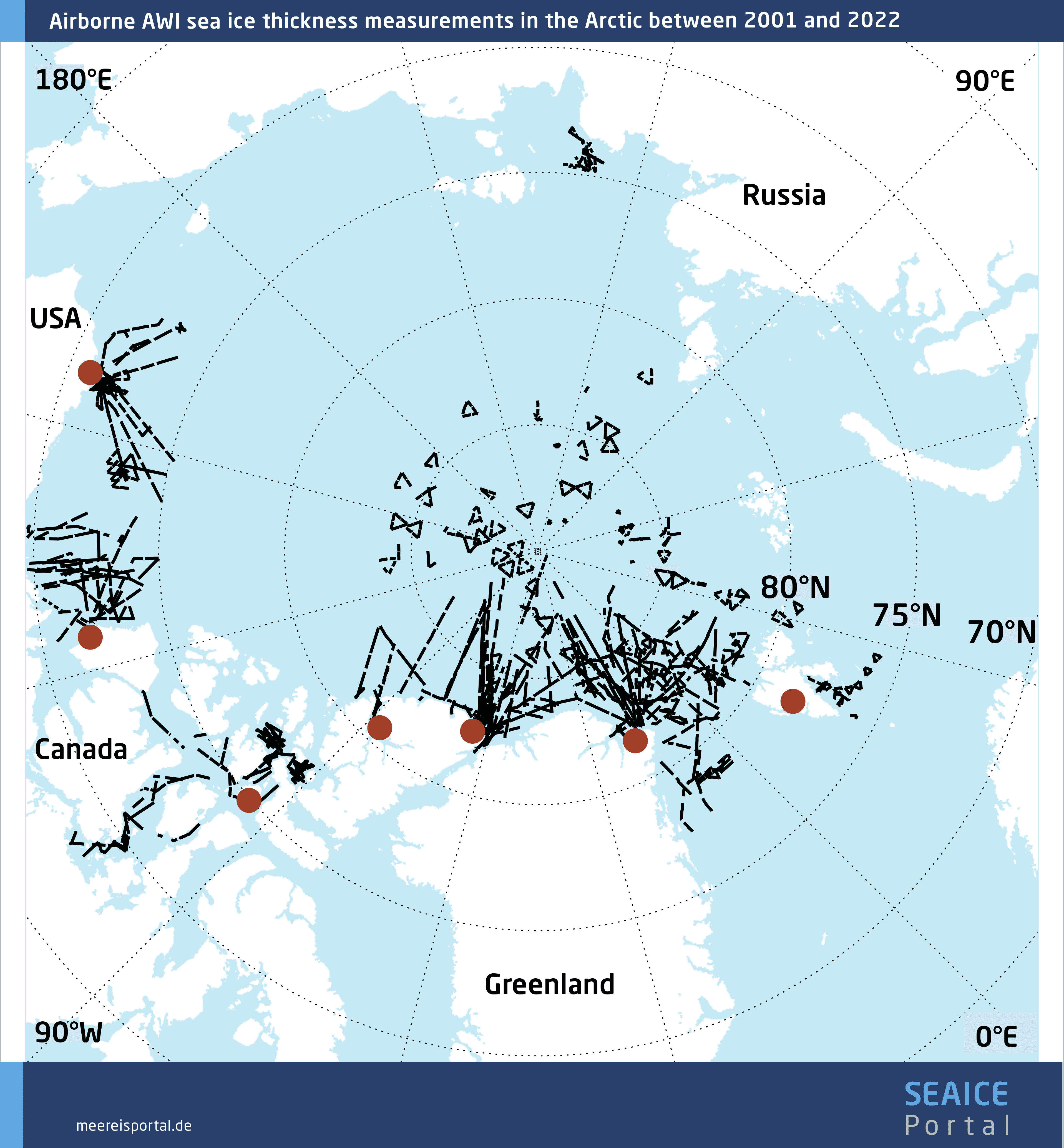
In some cases, there are several aerial campaigns over the sea ice with the two research aeroplanes per year. The data gathered makes it possible to gauge the variability of and changes in the sea-ice thickness and surface characteristics in remote yet essential regions of the Arctic and Antarctic. One particularly important monitoring programme: IceBird, which began in 2009. Here, every year the sea-ice thickness and surface characteristics in the Central Arctic are recorded at the end of winter (April) and end of summer (August).
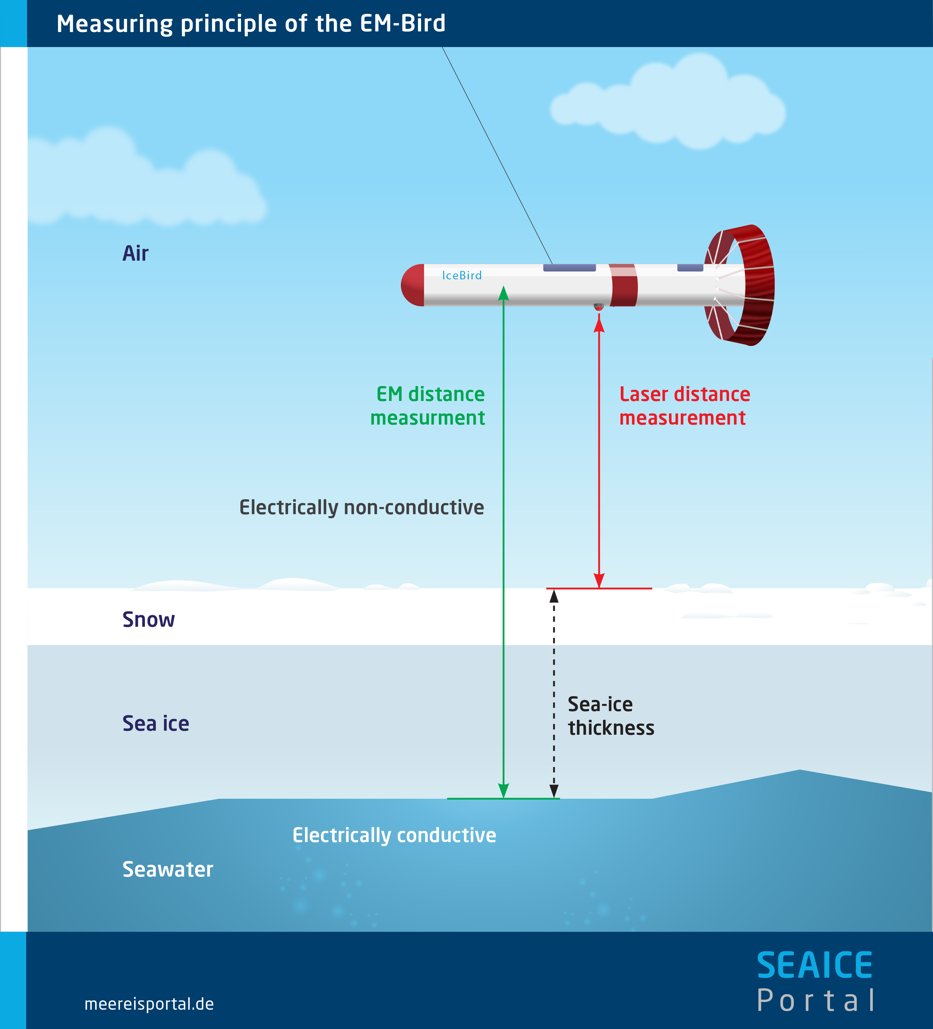
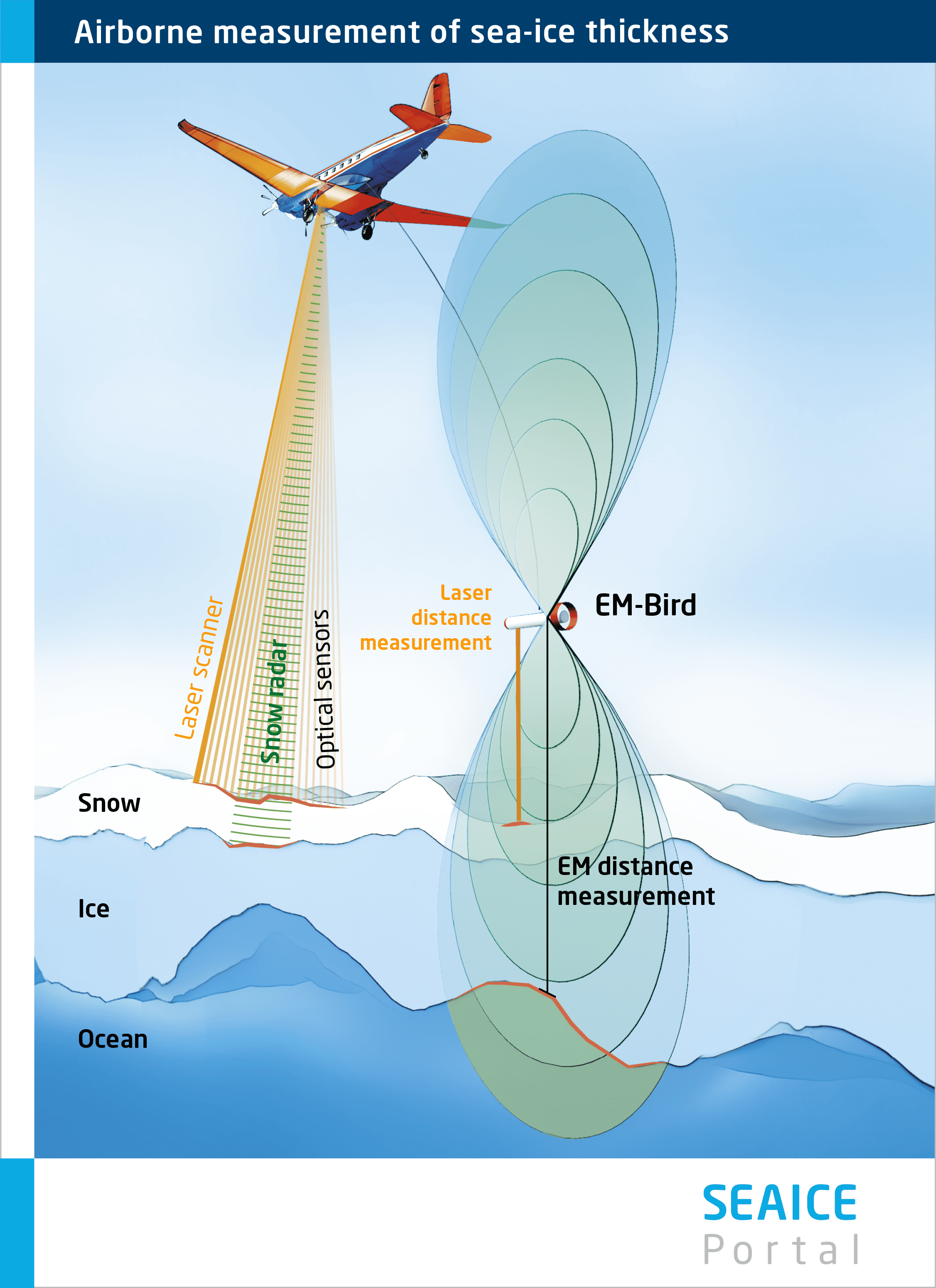
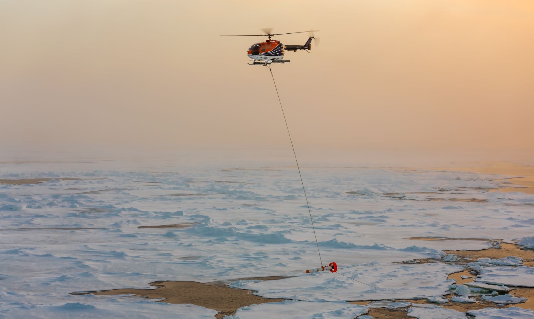
The thickness of the sea ice is measured in flight with the aid of an electromagnetic system (EM-Bird). The probe is suspended from a ca. 70-metre-long cable and towed at a height of 15 metres over the ice (Figures 2 and 3). At the same time, a laser scanner creates a high-precision elevation model of the ice’s surface, while a snow radar system measures the snow thickness (in winter). In summer, optical sensors like the DLR’s MACS camera are also used, yielding information on e.g. the sea ice’s ability to reflect sunlight (albedo) and on the distribution of melt ponds.
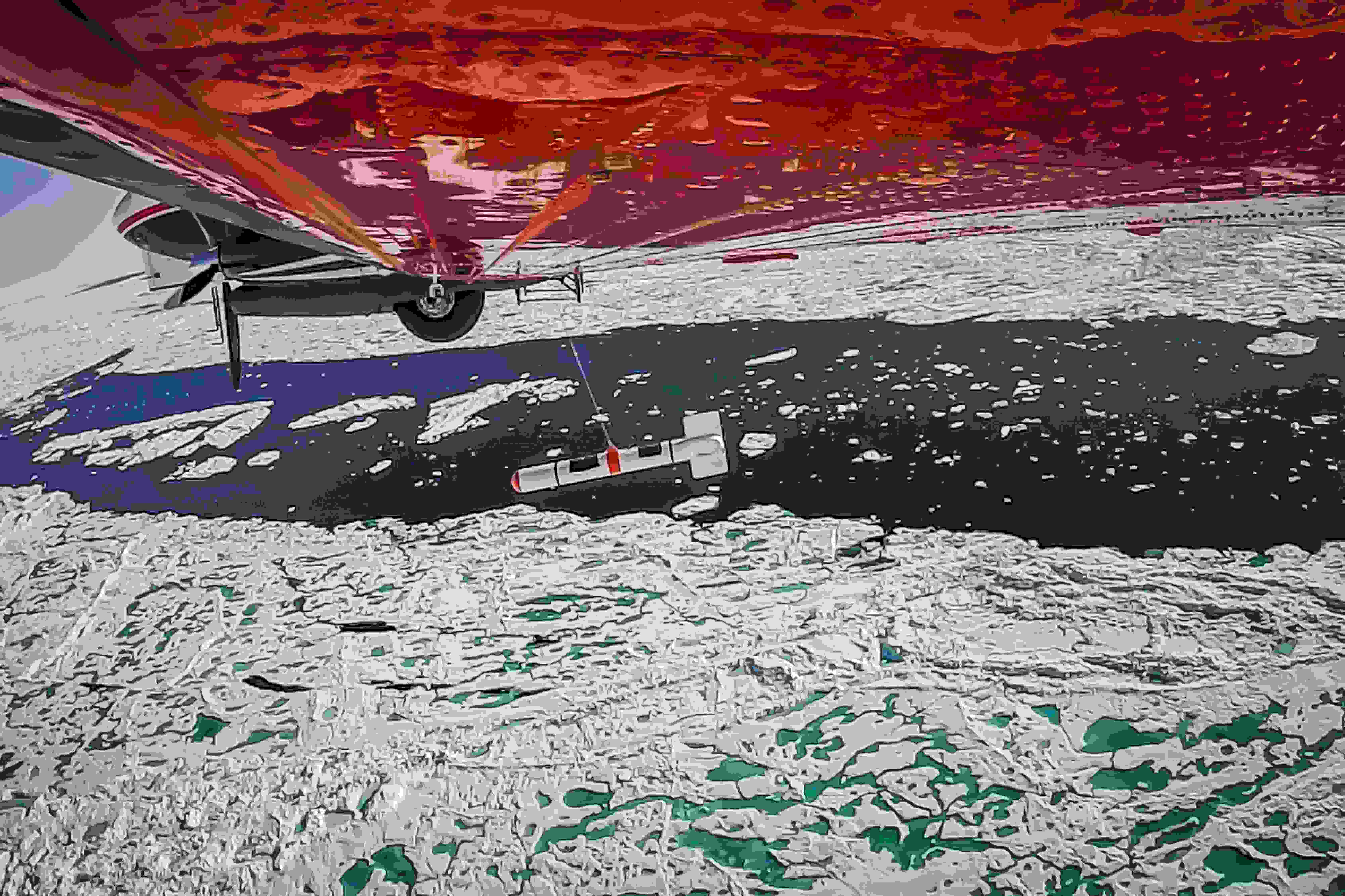
The research icebreaker Polarstern is equipped with two on-board helicopters (Figure 4). During ship-based expeditions in the Arctic and Antarctic, they can be used to drop researchers off to take readings directly on the ice. In addition, sea-ice thickness measurements can be taken using an electromagnetic probe (the EM-Bird) towed below the helicopter. The first thickness measurements using a helicopter and the EM-Bird took place in 2001. But other sensors – e.g. a laser scanner and optical camera systems – permanently mounted in the copter are also used. Fog and other adverse weather conditions can greatly limit the use of helicopters over sea ice. Nevertheless, in summer – particularly when optical sensors are used – they can provide valuable information on the surface characteristics of sea ice, which dictate the exchange of energy and momentum between the atmosphere and sea ice. Two of the most important parameters are the ice’s ability to reflect sunlight and the distribution of melt ponds on its surface.
Constant advances in unmanned aircraft or drones make then increasingly interesting as carrier systems for sensors that have to date only been used in manned aircraft. Currently, optical data is mainly used for documentation purposes and the photogrammetric recording of smaller areas. In comparison to manned aircraft, here the chief advantages are the far lower costs and the ability to engage in flights that couldn’t be attempted with a helicopter for safety reasons. The disadvantages are the drones’ comparatively low range and serious limitations on the sensors, since using different sensors simultaneously is not always possible. In the foreseeable future, not only optical sensors but also instruments covering other frequency ranges (e.g. RADAR or LiDAR will be important tools. In addition, thanks to improving battery performance, the range of unmanned aircraft is steadily growing. And today, drones are already being used to affordably glean valuable information on surface characteristics, especially when combined with simultaneous in-situ measurements.
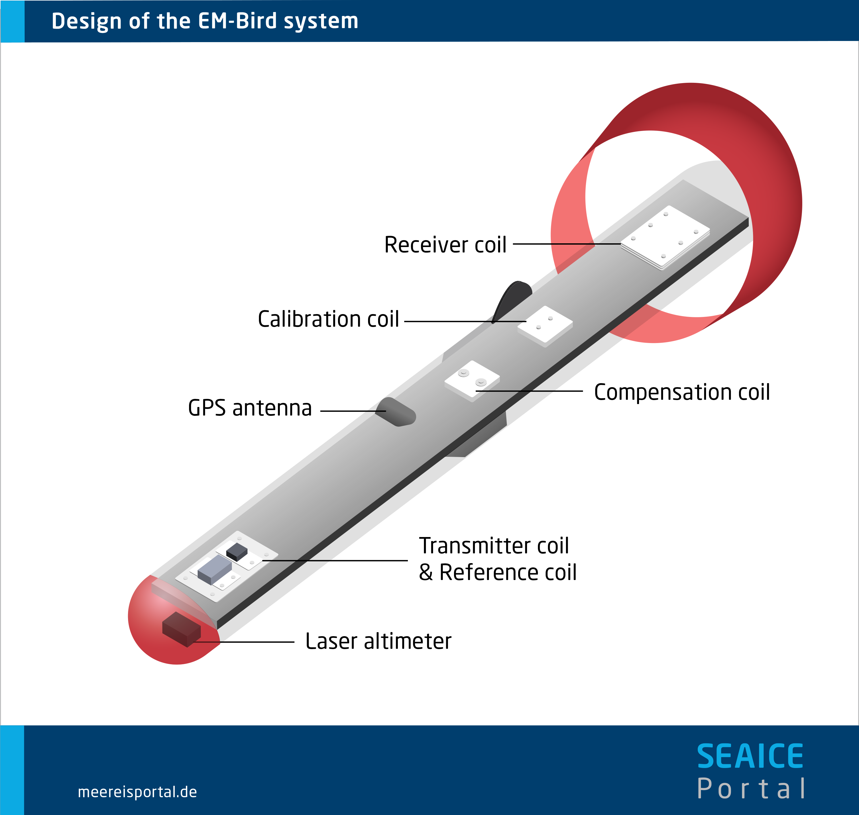
The EM-Bird is a sensor used with helicopters and aeroplanes to determine the thickness of sea ice. On the basis of the aerogeophysical electromagnetic (EM) induction process, it measures the electrical conductivity of the surface below. Since sea ice is characterised by high electrical resistance and seawater is highly electrically conductive, conductivity declines with increasing ice thickness. Consequently, the distance between the probe and the underside of the ice (surface of the seawater) can be determined electromagnetically. A laser altimeter is used to measure the distance to the ice’s surface, and the difference between the two distances is the total thickness, i.e., the thickness of the ice and the snow cover.
Until 2009, the AWI’s EM-Bird was exclusively deployed with helicopters. It was first used during a Polarstern cruise to the Arctic in 2001. When the Alfred Wegener Institute’s research aeroplanes Polar 5 and Polar 6 are employed, flights of up to 400 nautical miles (ca. 740 km) are possible, depending on the equipment on board.