The stratosphere is the part of our atmosphere beginning at an altitude of ca. 10 km, and where, thanks to the absorption of the trace gas ozone, temperatures rise with increasing altitude. Normally, water vapour and clouds never reach the stratosphere; accordingly, conditions are usually dry and clear.
However, since early August 2019 we’ve been monitoring a persistent aerosol layer in the stratosphere over our Arctic monitoring station AWIPEV on Spitsbergen. Aerosols are small liquid or solid particles that are swept up into the atmosphere by the wind, and can stem from both natural (desert sand, sea salt crystals, or soot and ash from wildfires) and anthropogenic sources, including factory chimneys and vehicle emissions. Though we know these aerosols can influence cloud formation, their effects on the climate remain poorly understood. Since they reflect a portion of solar radiation, acting as an additional ‘shield’ in the atmosphere, aerosols produce a global cooling effect in the climate system. That being said, during the Polar Night, they – just like greenhouse gases – can reflect part of the Earth’s infrared radiation back to the surface, producing a warming effect. Consequently, the uncertainties concerning aerosols in climate models are correspondingly high. In order to better assess their effects, climate models would have to accurately take into account the time of year, the altitude at which they appear, and their chemical composition.
Aerosols in the stratosphere
Normally aerosols are washed away again by the precipitation in clouds. Further, gravity gradually pulls the larger particles back down to the surface; as a result, aerosols only remain in the lower atmosphere for a few days to a few weeks. But major volcanic eruptions can spew gases up to the stratosphere, which grow into aerosols over months. Thanks to the lack of humidity, there are virtually no clouds, and aerosols can linger for several months, during which air currents spread them around the globe. This combination of factors produces a phenomenon known as ‘volcanic winter”, i.e., it helps shape the global climate. Once they reach the stratosphere, aerosols reflect sunlight back into space. Less sunlight gets through, as a result of which the global mean surface temperature drops, while the temperature in the upper atmosphere rises.
Although volcanoes are generally considered to be the main source of stratospheric aerosols, major wildfires can also be a problem. The (rare) combination of a wildfire and storm cell is widely considered to be an efficient mechanism for launching the particles and gases that form aerosols into the upper atmosphere.
But when wildfires produce a lasting aerosol layer in the Arctic, it’s something to write home about. Using a device specially designed for aerosol research, a lidar (light detection and ranging), we’ve been able to observe aerosol layers in the Arctic stratosphere since early August. Lidar works similarly to conventional radar: it fires a powerful laser burst into the atmosphere, and the aerosols reflect part of the light back toward the surface, where it is measured using a telescope. Since the elapsed time between the firing of the pulse and the arrival of the reflected light can also be measured, lidar systems can deliver complete vertical profiles, allowing researchers to scan part of the atmosphere.
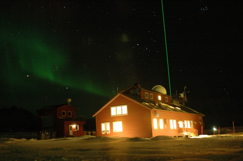
Figure 1 shows the AWI’s aerosol lidar at the AWIPEV research station on Spitsbergen during the Polar Night. What looks like a solid green laser beam coming the roof of the observatory actually consists of 50 bursts of light per second, but neither the human eye nor the camera shutter is fast enough to capture them. The result: we think we’re looking at a steady beam of light.
Monitoring the stratospheric aerosol layer on Spitsbergen
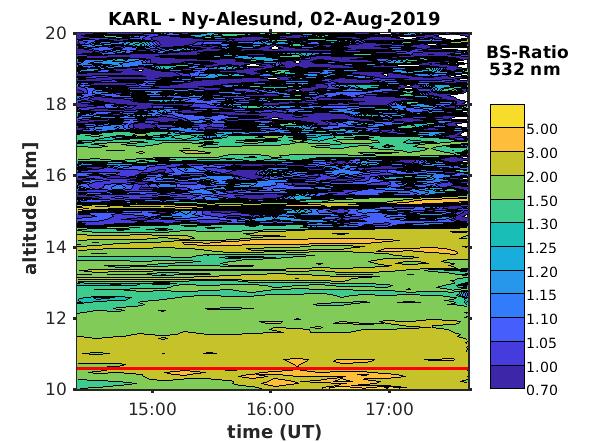
Stratospheric aerosols from the wildfires in the summer of 2019 were first observed on 2 August 2019. Figure 2 uses a time-and-altitude profile to depict the backscatter ratio – a parameter that shows to what extent the reflectivity exceeds the level produced by normal air molecules. The scattering effect of air molecules is the reason why we see a blue sky during the day, instead of the stars and brilliant sun on a pitch-black background that we would see from the moon. If the ratio is greater than one, it indicates the presence of additional particles: aerosols. The horizontal red line in Figure 2, at an altitude of ca. 10.5 km, represents the division between the troposphere and stratosphere (the tropopause) on the respective day. As can be clearly seen, part of the aerosol layer is in the upper stratosphere, at altitudes of up to ca. 17 km. In some areas, the backscatter is three times higher than normal. Figure 2 also makes it clear where the stratosphere (Greek: ‘layered [air] sphere’) got its name: as previously mentioned, the higher in the stratosphere you go, the more temperatures rise. Warm air naturally expands, making it lighter than cold air. As a result, when warm air is above cold air, the layers remain stable and there is no vertical exchange of air masses between the two. Once aerosols reach a given altitude, they stay there, producing an unmistakable, ‘striped’ pattern.
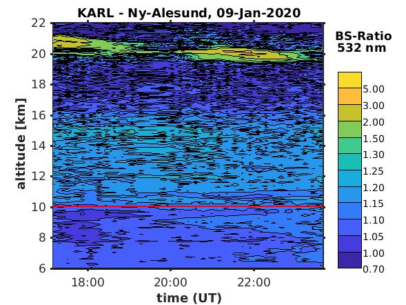
Figure 3 shows the same physical parameter five months later. The aerosol layer, at altitudes between 10 km and 16 km, is now considerably weaker, with a ratio only 25% higher than clear air (backscatter ratio: 1.25). Thanks to the countless clouds in the past few months, the aerosols have long since vanished from the troposphere; but in the stratosphere, thanks to the dryness and lack of vertical mixing, they have endured.
At an altitude of 20 km to 22 km we can see another phenomenon, which we’ll only briefly mention here: what is technically referred to as a ‘polar stratospheric cloud’ (PSC). It’s the only type of cloud in the stratosphere that only forms at extremely low temperatures during the Polar Night. So we can currently see two very different and unusual phenomena, both produced by aerosols and their effects on cloud formation, in the normally clear stratosphere over our station on Spitsbergen. “As is so often the case, Mother Nature has a few tricks up her sleeve – but if you look very closely and ask the right questions, you’re often rewarded with surprising insights,” says Dr Christoph Ritter, an atmospheric physicist at the AWI in Potsdam with a wry grin, before adding: “It’s too soon to quantify the effects of this unusual stratospheric aerosol concentration on the sea-ice formation this winter. But this is an area of research that is being investigated – by the ATMOSPHERE team on the MOSAiC expedition, and in the form of extensive measurements and probe work done both on the MOSAiC floe and at land-based stations like AWIPEV – so that it can be more accurately reflected in future climate models. It’s imperative that aerosols be explicitly considered in the next generation of climate models, and the readings we’ve taken this winter show that we still have a long way to go before we’ve fully understood them!”
Contacts
- Dr Christoph Ritter (AWI)
- Dr Renate Treffeisen (AWI)
Questions?
Contact us via E-Mail or our contact form.
Graphics


