But this year, February was extraordinarily warm. Analyses of satellite and station data indicate that very warm air has been advected towards the Arctic, which allowed temperatures to rise until the freezing point.
„At the moment the situation in the Arctic is characterized by much warmer than usual temperatures (with more than 10°C above the mean value in the central Arctic) and by extremely low sea ice coverage, which has never been this low in February since the satellite measurements began“, emphasizes Prof. Christian Haas, head of the Sea Ice Physics section at AWI.
In February, the Arctic sea ice showed the lowest value ever observed for this month (see Figure 1), with a monthly average of 13.94 million km2. This value was even smaller compared to the sea ice coverage in February 2007 (14.51 million km2) and 2012 (14.25 million km2) – in both years the summer sea ice extent in September showed record lows. Besides, the observed value is also below the long-term two-fold standard deviation of the sea ice extent (Figure 2). The spatial distribution of sea ice cover shows a particularly low extent in the Bering Sea, on the East coast of Greenland, east of Spitsbergen and in the Barents Sea compared to the long-term mean (Figure 3). Especially dramatic was the loss of sea ice in the Bering Sea. There, the ice cover shrunk dramatically within a few days (Figure 3).
Arctic sea ice condition in context
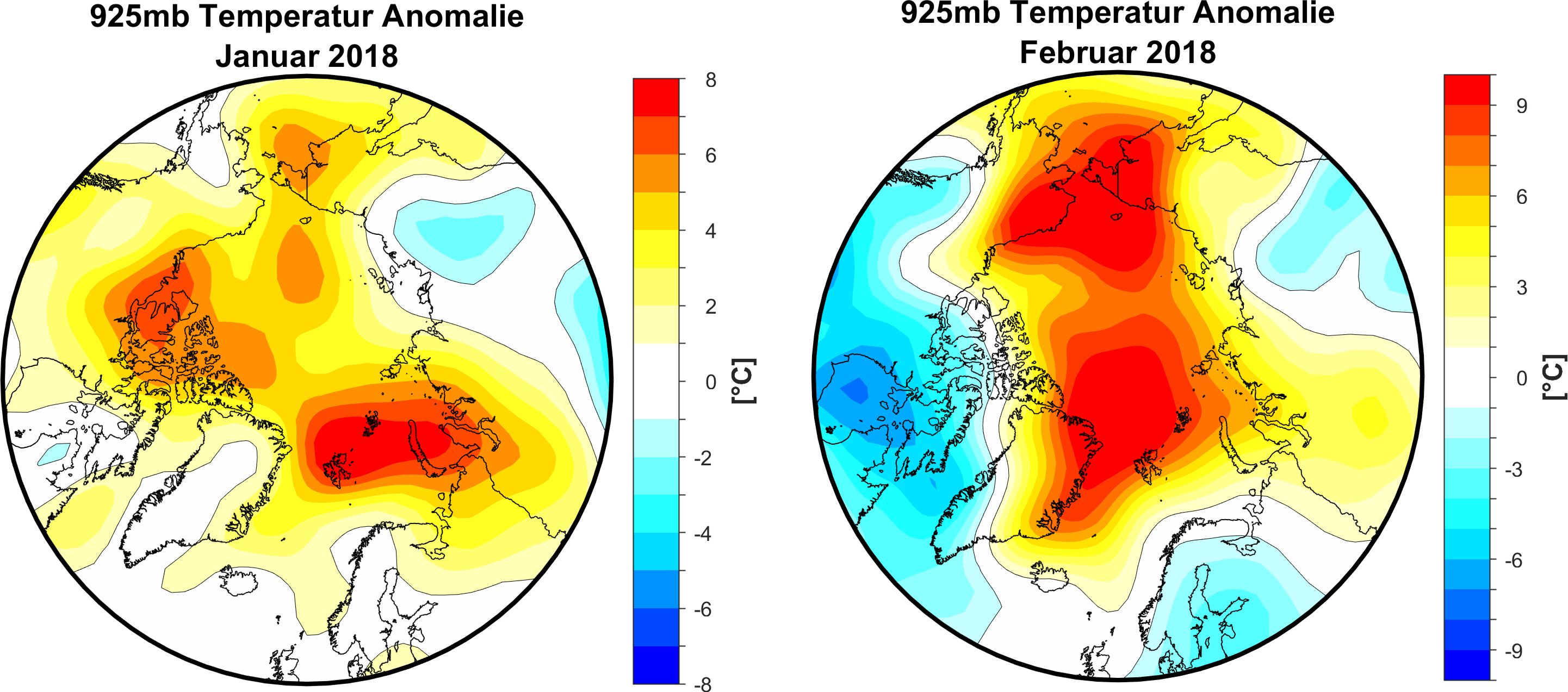
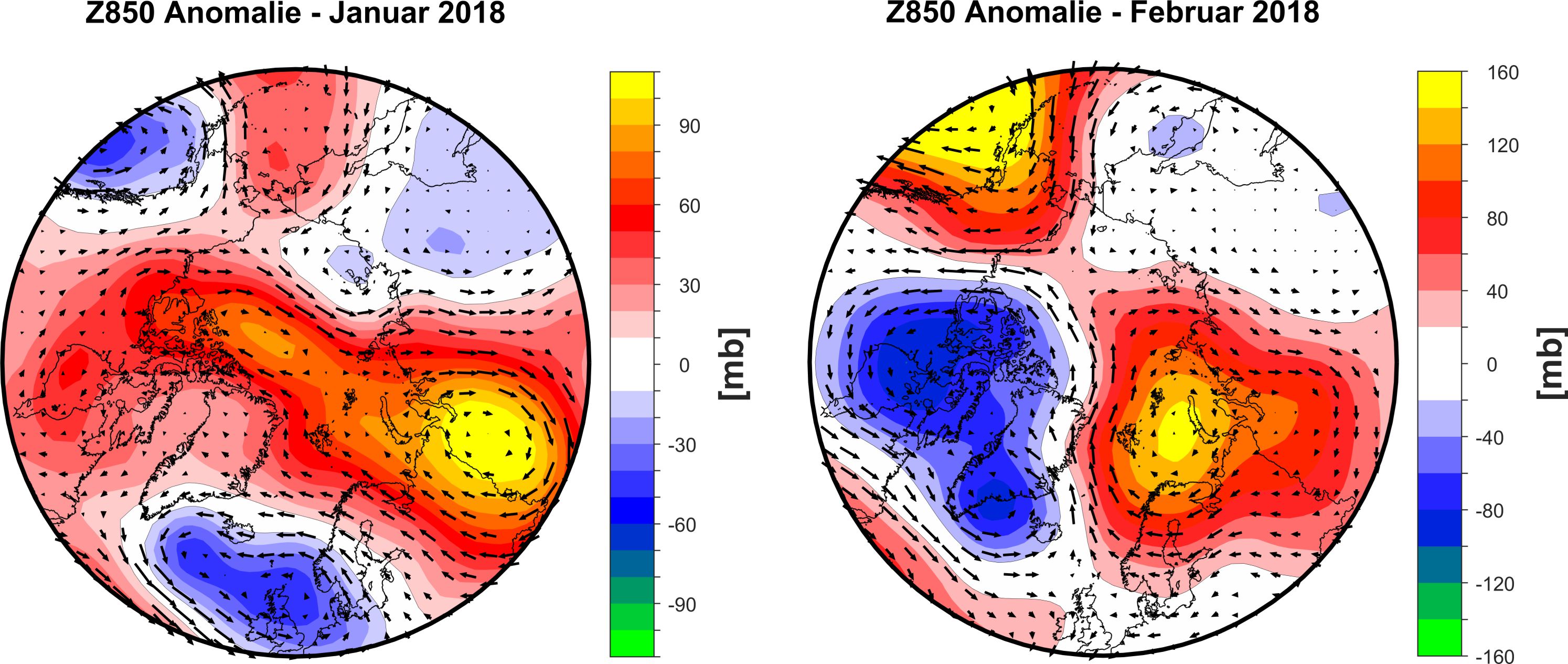
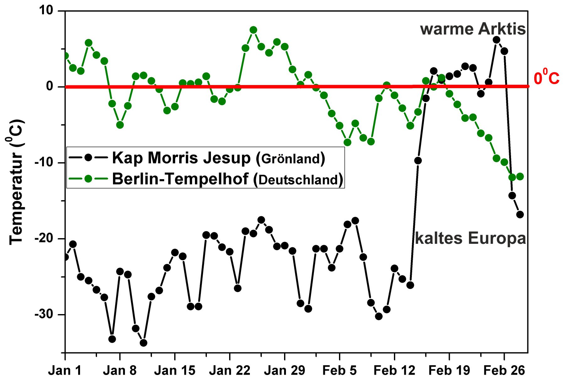
Already in January many parts of the Arctic experienced higher temperatures compared to the long-term average (Figure 4). The second half of February was characterized by extreme weather conditions, with particularly high temperatures over the Arctic and extremely low temperatures over Eurasia and North America (Figure 5, right side). This was caused by the prevailing large-scale atmospheric circulation over the Arctic region. While in January an extensive high-pressure system (Figure 6, left side) over Western Russia and a low-pressure system over the Northern North Atlantic caused a zonal wind circulation, in February the large-scale atmospheric circulation was characterized by a dipole-like system featuring a high pressure system over the Kara Sea and a low pressure area over Greenland and the West coast of the USA. As a result of this large-scale atmospheric dipole-like structure, the warm and humid air masses from the Atlantic were directed northward into the Arctic (Figure 6, right side). This is observable in the daily mean temperatures measured by the AWIPEV monitoring station at Spitsbergen/Svalbard (Figure 7), which shows peak temperatures above freezing point being on average about 5°C warmer than the long-term average for this time of the year. The extremely warm temperatures in the Arctic become obvious when comparing daily temperature measured at a station from the northernmost point of Greenland and daily temperature data measured in Berlin (see Figure 8). The time series of daily mean temperature in January and February in Kap Morris Jesup (Greenland) and Berlin (Germany) show an abrupt rise of the daily mean temperature in Kap Morris Jesup from around -25°C to above 0°C starting from 14th February and a simultaneous temperature decrease in Berlin from above 0°C to -12°C. The peak temperature in Northern Greenland was measured on 25th February with around +6°C.
Such extremely warms days in the Arctic, throughout the winter months, have been very seldom in the past, but become increasingly common today. A study published in July 2017 discovered that such events have been more prevalent since 1980, more intensive and longer lasting (Graham et al., 2017). According to the authors, such events occurred four times between 1980 and 2010, while they have been seen in four of the past five years. „We can expect these events to become even more common in the future as they are related to global warming and declining sea ice“, stresses Christian Haas. This year’s extremely warm Arctic, especially in February, is the result over interplay between different factors. „Due to the high pressure systems over Scandinavia and the Barents / Kara Sea the stromtracks have been shifted to the North Pole and Greenland. Warm and humid air had advanced until the central Arctic which resulted in this extraordinary situation. The ocean temperatures of the Greenland Sea are also warmer than usual during this time of the year, which further intensifies this warming event“, explains Dr. Monica Ionita-Scholz, climatologist at AWI. The second part of February 2018 has been marked by extreme weather conditions, with exceptionally high temperatures over the Arctic basin and extremely cold temperatures over Eurasia. This abnormal situation is the results of a Sudden Stratospheric Warming (SSW) event in the second week of February 2018, which occurred high up in the stratosphere. This SSW was caused by a huge rise in air temperature in an area about 30 km above the North Pole. The SSW led to a split in the polar vortex (see animation Figure 9), which in turn led to a disruption and weakening of the jet stream, allowing warm and moist air from the Atlantic and Pacific basins to be advected towards the Arctic circle and, in return, cold air from Siberia to be advected over Europe (see animation Figure 10). When the jet stream becomes wavier, colder air can penetrate further south and warmer air further north. The weak and displaced polar vortex pushed the jet stream further south, leading to the development of a blocking high pressure system over Scandinavia and Barents/Kara Seas (Figure 6). This system stayed stable for some days and led to warmer conditions in the Arctic and to the bitter cold days over Eurasia. „This is an impressive and very rare situation that we currently can witness in the Arctic. Nevertheless, the extremes observed, especially over the last few years, indicate that the future of the Arctic will be full of inevitable surprises“, adds Monica Ionita-Scholz. In summary, it can be noted that abnormal weather conditions in January and February this year led to enormous warmth and moisture input to the central Arctic. This resulted in a historical low sea ice extent, during the period when the sea ice extent winter maximum usually occurs. This development could precondition the Arctic ice conditions in a way that the date of the maximum spring sea ice extent could happen earlier. „At the moment we are not able to predict to what extent this will influence the Arctic summer ice conditions because weather and wind conditions during summer are even more important for the development during melt season than the winter conditions. However, it is indisputable that the advancing sea ice decline as a result of global warming left an explicit footprint in the Arctic during this winter“, stated Christian Haas.
Further reading
Graham, Robert M., Cohen, Lana, Petty, Alek A., Boisvert, Linette N., Rinke, Annette, Hudson, Stephen R., Nicolaus, Marcel, Granskog, Mats A.: Increasing frequency and duration of Arctic winter warming events, DOI: 10.1002/2017GL073395, Geophysical Research Letters, 2017.
Contacts
Questions?
Contact us via E-Mail or our contact form.
Grafiken


 and Berlin (Germany).")
.")


 and Berlin (Germany).")
.")
