After the sea-ice extent in the Artic reached its winter maximum on 12 March 2019, the melting season in the North Pole region began and soon reached an all-time low for the time of year (23 April 2019). “Since the end of March, we’ve been seeing new negative record values on a daily basis,” says Dr Lars Kaleschke, a sea-ice physicist at the Alfred Wegener Institute, assessing the current situation in the Arctic. “The further progression of the sea-ice retreat and the ice conditions next summer will also be very exciting for us in connection with the launch of the MOSAiC expedition, which will take our research icebreaker Polarstern to the Central Arctic for an entire year, starting in mid-September.”
A retrospective on this year’s winter maximum
In March, the mean Arctic sea-ice extent was 14.32 million square kilometres. The extent reached its maximum of 14.69 million km² on 12 March 2019 (Fig. 1). The mean sea-ice extent for March, at 14.32 million km², is the fourth-lowest extent in the 40-year time series since the beginning of regular satellite observations in 1979 (Fig. 2). It lies ca. 1 million square kilometres below the mean value from 1981 to 2012, and 104,547 square kilometres above the lowest-ever mean value for March, recorded in 2017.
An increase in sea-ice extent was monitored in the Bering Sea, which had been virtually ice-free in early March (see News item), at mid-month. However, the phenomenon proved to be short-lived; the last week of March was characterised by a significant reduction (Fig. 3). The Bering Sea normally reaches its maximum sea-ice extent in late March or early April. In contrast, this year the maximum was reached in late January and was 34.5 percent below the average maximum for the period 1981 to 2010 (source: NSIDC). This lack of sea ice in the Bering Sea in late March accelerated overall Arctic sea-ice retreat. On 1 April the Arctic sea-ice retreat was already at an all-time low for this date (Fig. 4).
The winter 2018/2019 can be classified as a mild one. For broad expanses of the Arctic Ocean, the atmospheric temperatures at 925 hPa were average to slightly above average. Only the southern Beaufort Sea was especially warm, with temperatures 5 degrees Celsius above average. Throughout the winter, the sea-ice extent hovered near the lower boundary of the two-standard-deviation range from the long-term trend since 1979.
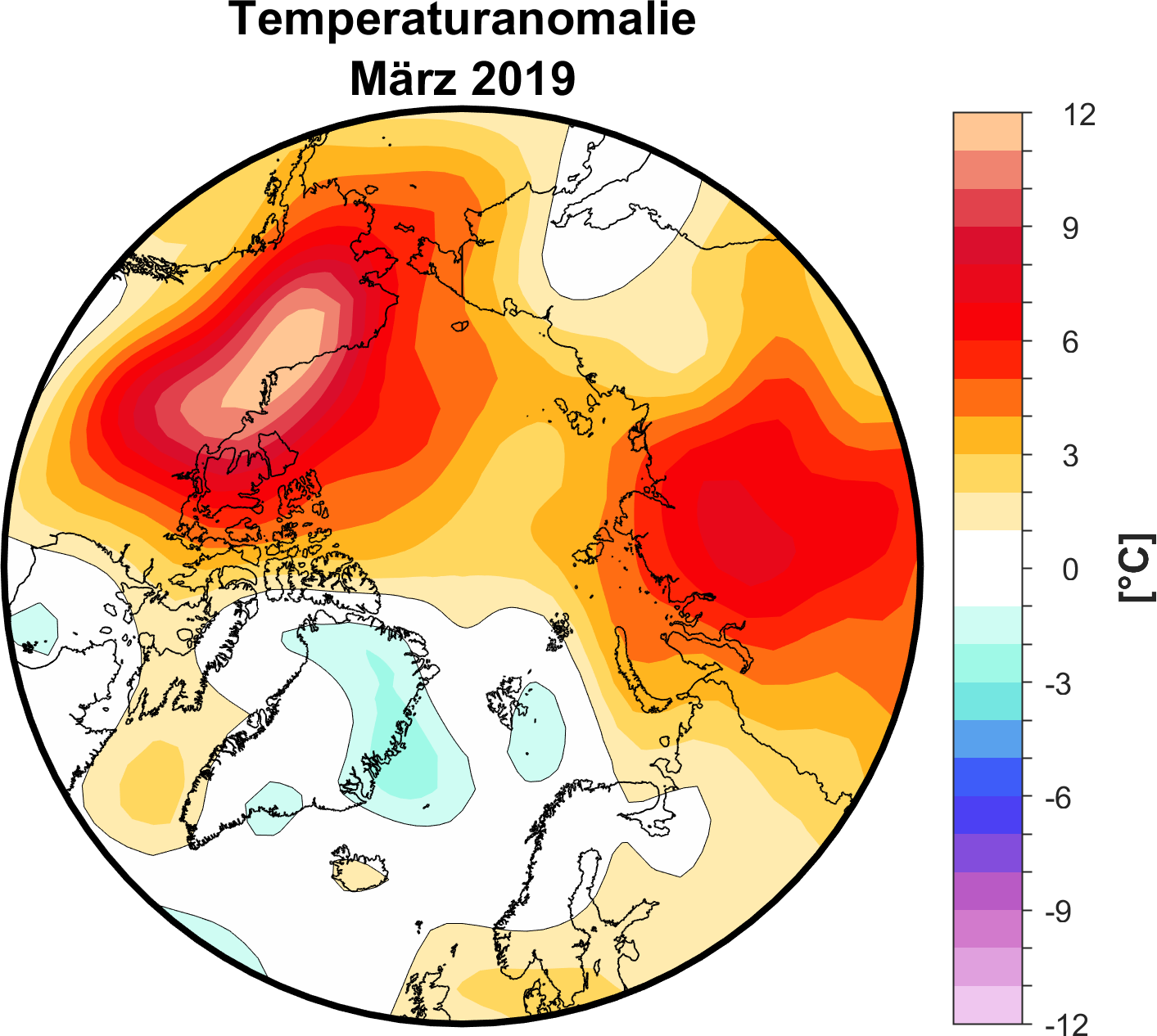
With regard to the atmospheric pressure at sea level (Fig. 5), over the Bering Sea and major regions of the Eurasian side of the Arctic Ocean, below-average values were predominant. That being said, the circulation patterns weren’t particularly unusual, and there were no pronounced short-term warm phases akin to those observed in previous winters (Fig. 6). On average, the temperatures in March were up to 10°C above the long-term average in the Beaufort Sea, northeast Alaska and northwest Canada. For much of the Arctic, the sea-ice extent was above average for the majority of the winter.
Start of a melting phase and melting trend in April
With the beginning of the melting season, there was a substantial amount of ice retreat in the Sea of Okhotsk and Bering Sea, as well as the Davis Strait, west of Greenland. At the end of the month, small patches of open water were evident in the sea-ice fields observed by the University of Bremen, particularly near the coasts of the Laptev Sea, Kara Sea, and Sea of Okhotsk, as well as the northwest coast of Alaska. Consequently, the Arctic has experienced an unprecedented level of sea-ice retreat since the beginning of April, and the mean sea-ice extent lies ca. 520,000 square kilometres below the previous low in 2017 (Fig. 4 and 7).
This extensive sea-ice retreat in the Arctic is due to prevailing low pressures, combined with unusually high temperatures. Two low-pressure centres, one over the Bering Sea and the other over the Barents Sea, dominated the atmospheric circulation. Though the low-pressure cell over the Barents Sea ensured cloudy and cool conditions in the immediate vicinity, warm air was nonetheless free to flow into the central Arctic Ocean. The atmospheric temperatures at 925 hPa (circa 750 m above sea level) were above average for much of the Arctic, with the exception of the Atlantic part of the Arctic Ocean. Temperatures were far above average – in some cases climbing above 10 degrees Celsius – over the Beaufort Sea, northeast Alaska and northwest Canada.
The general low-pressure cell over the Arctic in March manifested as a prolonged phase of positive Arctic Oscillation (AO), a pattern that began in the second week of February. In past years, a positive AO index has been conducive to a low September sea-ice extent. This is due in part to a wind pattern that drives older, thicker ice out of the Arctic and through the Fram Strait. In addition, the pattern tends to draw ice away from the Siberian coast, leading to a thinner layer of ice in the region, which is more prone to melting in the summer. That being said, given the general thinning of Arctic sea ice, the connection between AO phases in winter and the sea-ice extent in September is no longer as clear as it was once assumed to be.
The Antarctic autumn – slowly bouncing back
Summer passed its zenith in the Southern Hemisphere and the sea-ice extent in the Antarctic reached its summer minimum. Though there were indications of particularly intensive sea-ice retreat trend in early January, by the end of the month conditions had returned to normal. On 28 February 2019 the sea-ice extent in the Antarctic reached its absolute minimum at 2.53 million km²; the monthly mean value was 2.69 million km². This represents the seventh-lowest value after the ‘year of minimums’ in 2017 (2.45 million km²) and continues a series of summer months characterised by a sea-ice extent far below the long-term trend for recent years (Fig. 8 and 9).
Although, in comparison to 2017, particularly the Weddell Sea, the coastal areas of East Antarctica (Mawson Sea and D’Urville Sea) and parts of the Amundsen Sea were characterised by lower sea-ice extents, higher extents were observed in the western Ross Sea and Amundsen Sea, as well as the Lazarev Sea and Riiser-Larsen Sea in the Atlantic sector (Fig. 10).
The sea-ice growth in March 2019 was most pronounced in the central Ross Sea and northeast Weddell Sea, whereas the significant retreat in the southern Bellingshausen Sea continued unabated. Since the beginning of the freezing season, the sea-ice extent has remained near the lower boundary of the two-standard-deviation range from the long-term average for the period 1981-2010 (see Fig. 11). In keeping with the relatively slow ice growth, according to data from the NSIDC, atmospheric temperatures at 925 hPa were between 2 and 4 degrees Celsius above the long-term average for 1981 to 2010 for major sections of the Antarctic coast, from Wilkes Land to the Ross Sea, Amundsen Sea and Bellingshausen Sea; in contrast, temperatures along the coast of Queen Maud Land were 1 to 2 degrees below the long-term average. The atmospheric circulation at sea level was characterised by three regions with above-average atmospheric pressure and by areas with below-average pressure, which climate researchers refer to as the wave-3 pattern. In particular, the low pressure over the Amundsen Sea and high pressure over the Drake Passage (between South America and the Antarctic Peninsula) produced intense northwesterly winds on the southern peninsula, which accelerated local sea-ice retreat, whereas general sea-ice growth was observed in other regions.
Contacts
- Dr Monica Ionita-Scholz (AWI)
- Dr Lars Kaleschke (AWI)
- Dr Renate Treffeisen (AWI)
- Dr Klaus Grosfeld (AWI)
Questions?
Contact us via E-Mail or our contact form.
Graphics


