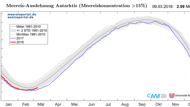
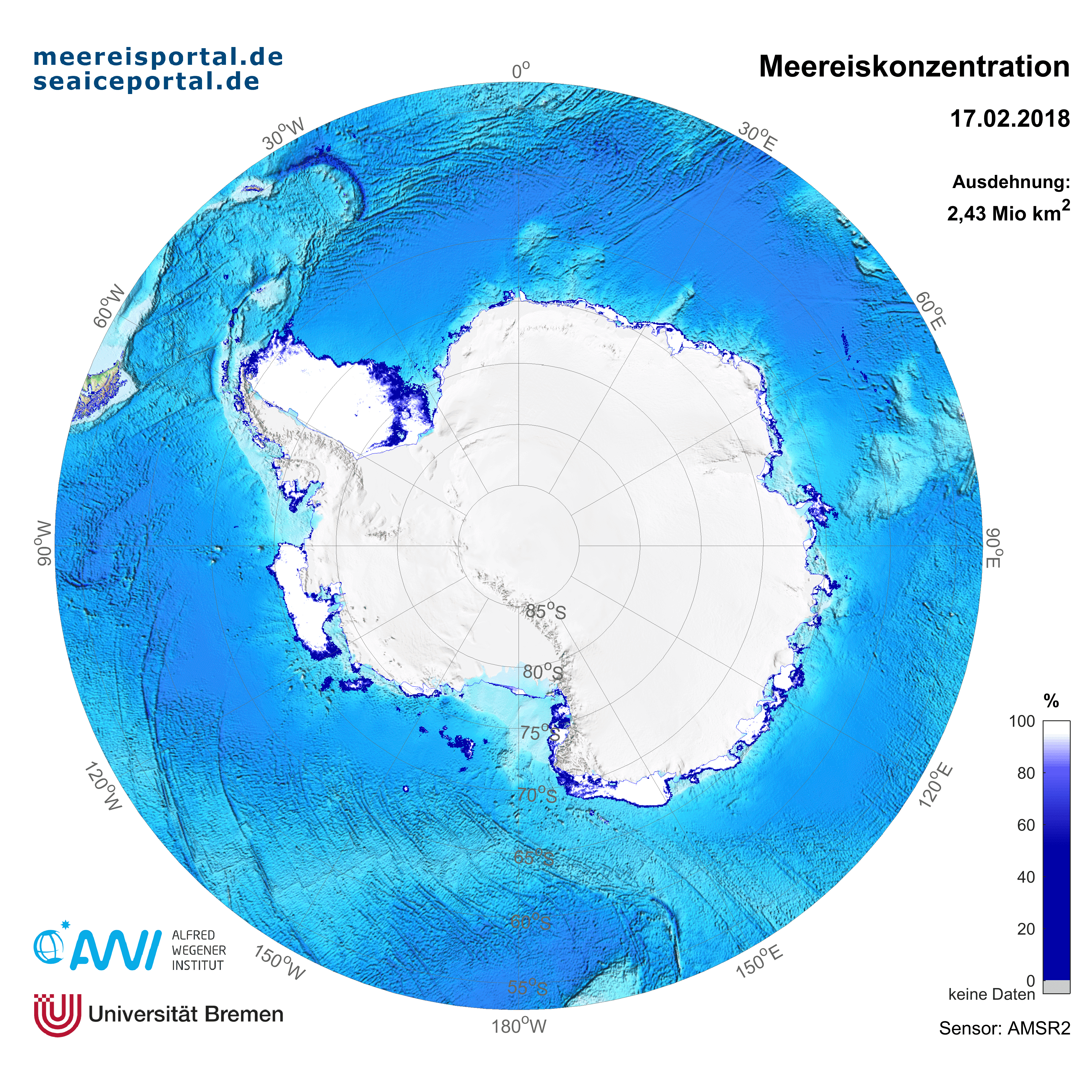
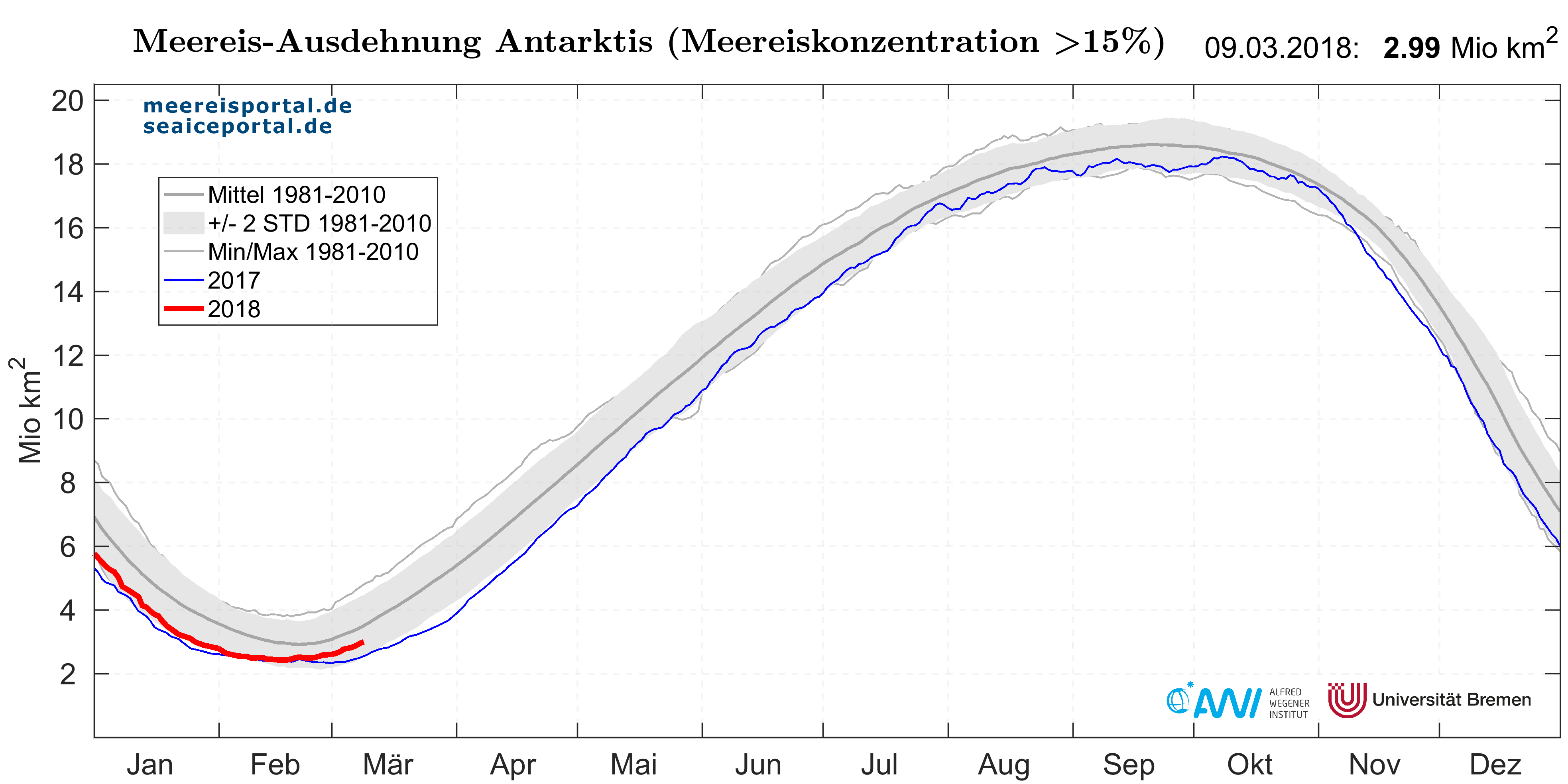
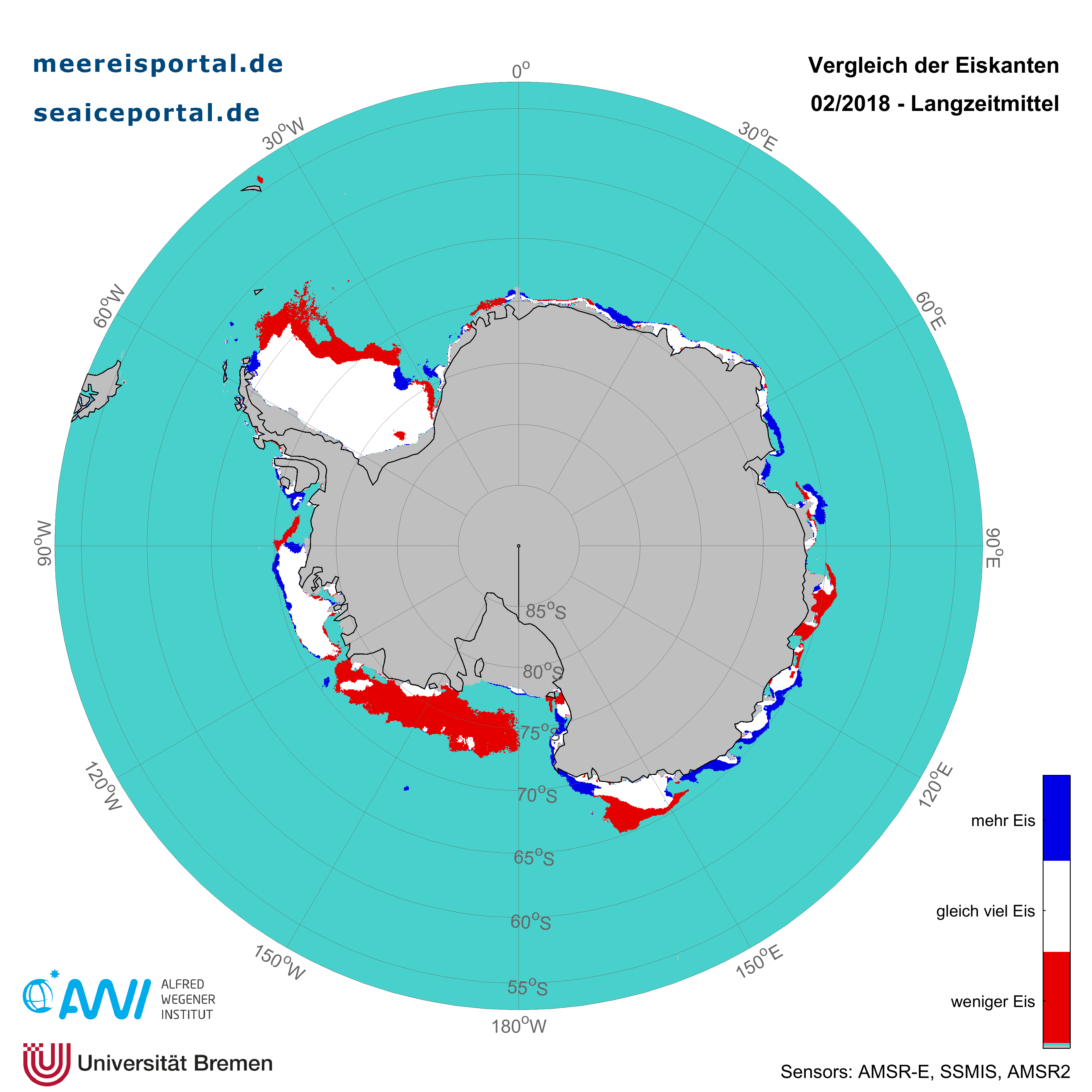
The sea-ice extent in the Antarctic is far more variable than in the Arctic. In February, the mean area was 2.52 million km², the second-lowest reading since the advent of satellite measurement and only roughly 74,000 km² more than the record low in 2017. The curve for this year’s sea-ice extent is currently in the lower two standard deviation (see Figure 2). The sea-ice extent is particularly low in the Ross Sea, Weddell Sea and the eastern Amundsen Sea (see Figure 3).
Antarctic sea-ice conditions during the latest (33rd) Polarstern expedition
The especially low amount of Antarctic sea-ice cover this summer meant extremely favourable conditions for the research icebreaker RV Polarstern, whose route took her to the southern Weddell Sea this year (Figure 4). A total of 51 researchers spent more than eight weeks investigating changes near the Filchner-Ronne Ice Shelf system – in the interdisciplinary context of interactions between the atmosphere, sea ice, ocean and ice shelf, and between biology and geology. While the sea-ice situation in the Antarctic as a whole is monitored by satellites, sea-ice physicist Dr Stefanie Arndt from the Alfred Wegener Institute spent the last eight weeks on location with the research icebreaker RV Polarstern, during which she took sea-ice measurements on numerous individual ice floes – important work that will help us better understand the sea-ice situation in the Antarctic.
According to Stefanie Arndt, who led the 5-member sea-ice team on this year’s expedition, the main purpose was to comprehensively explore the snow cover on Antarctic sea ice, especially in the Weddell Sea. In this regard, they sought to find answers to questions such as: ‘How thick is the snow cover? Were there internal snow-melting and freezing processes at work in the previous season? If so, where, and how intensive were they?’ As the AWI researcher explains, ‘Further, a typical phenomenon on Antarctic sea ice is referred to as ‘flooding’: when the snow cover on the sea ice gets too thick, it can cause the ice to sink below the waterline, and water can seep into the interstitial layer between the snow and ice. When the water refreezes, it forms what we call snow-ice.’
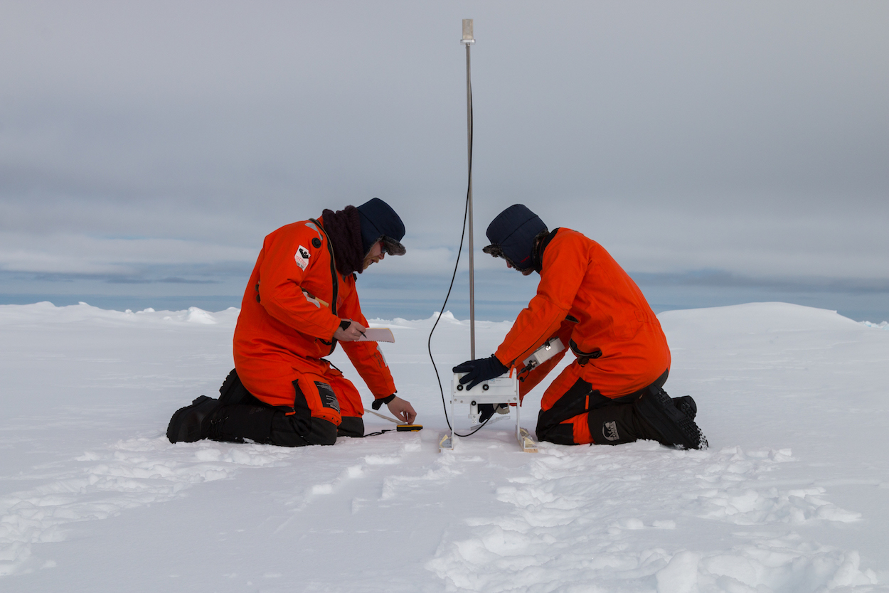
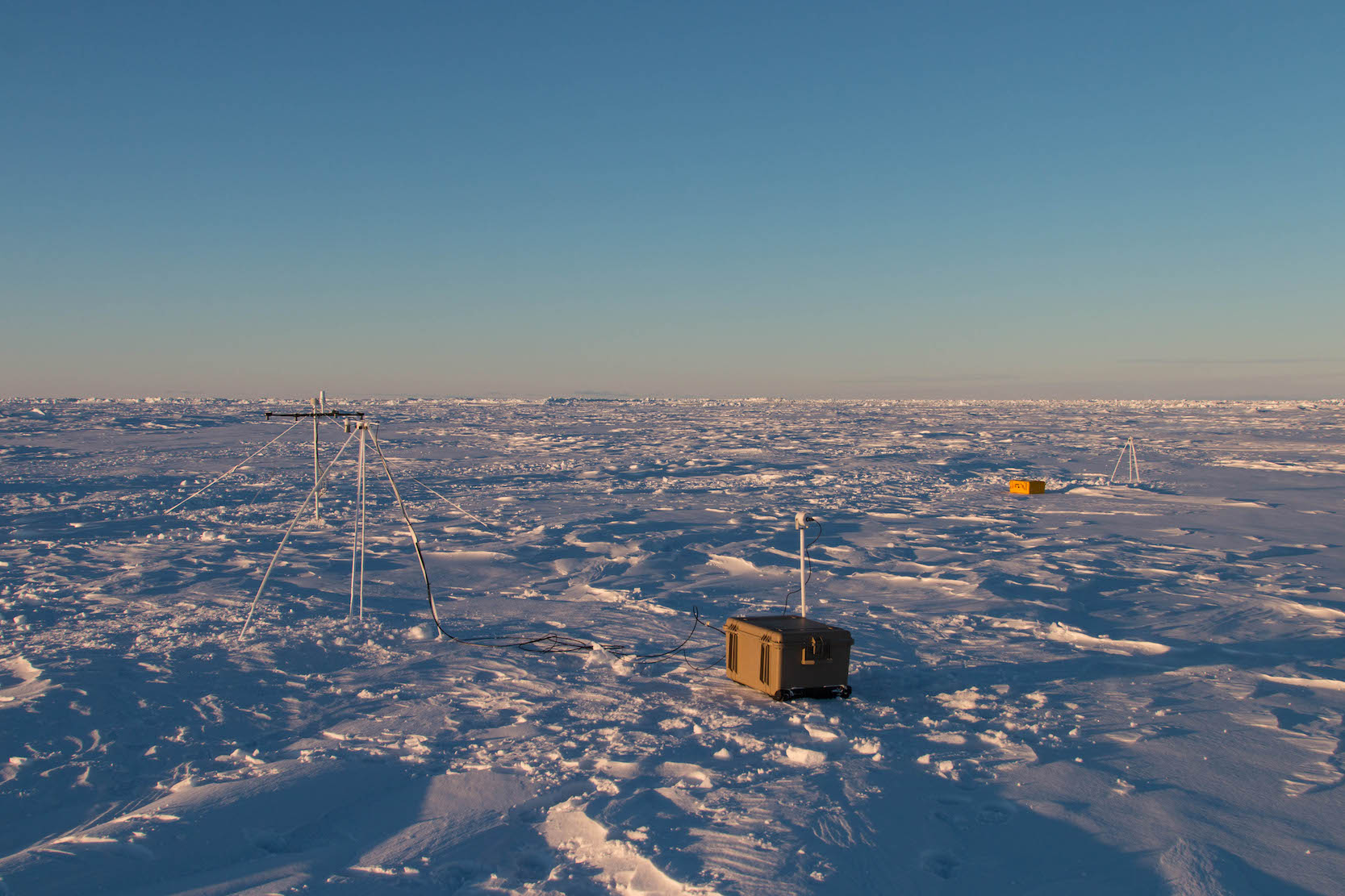
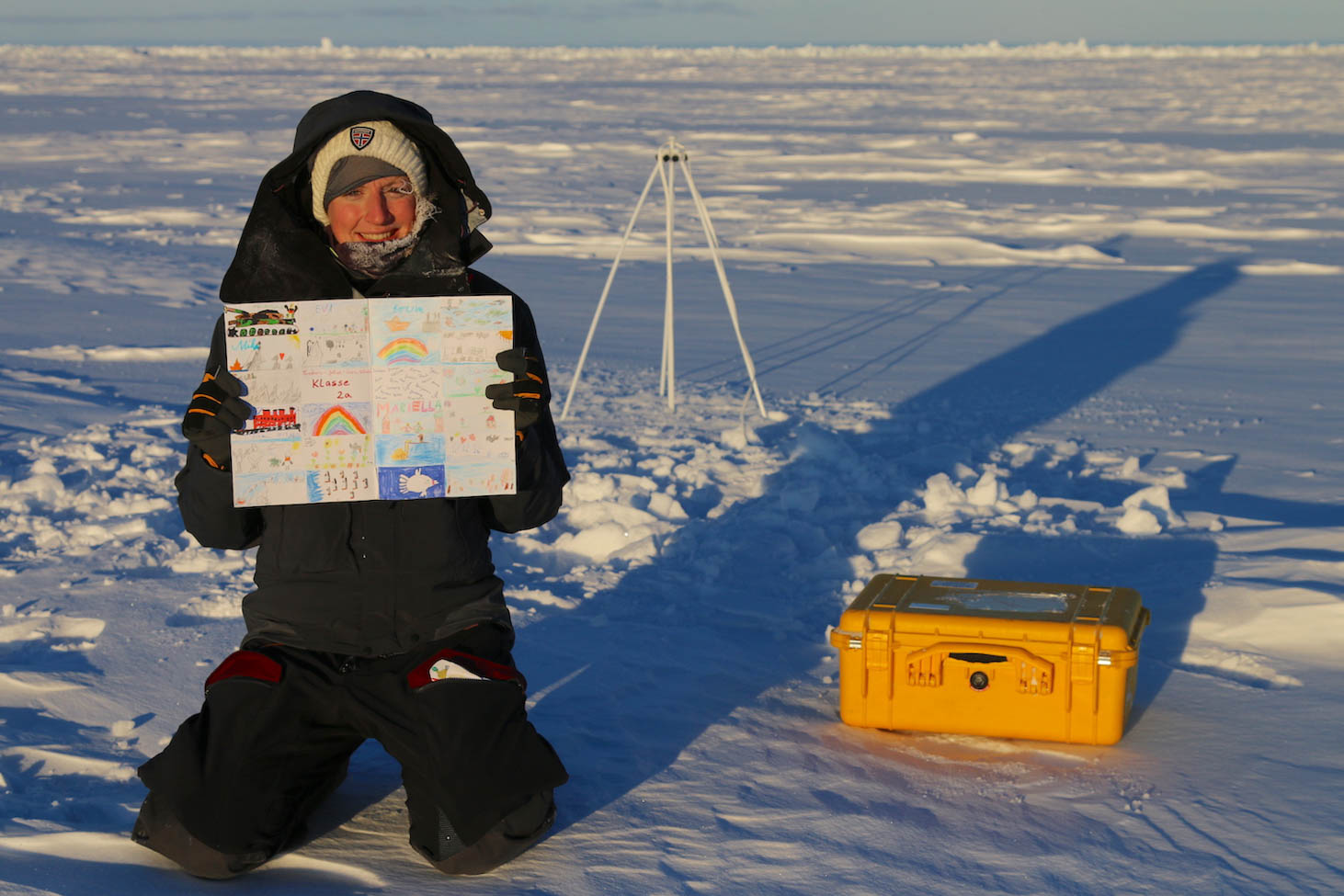
To investigate all of these properties in the field, the team dug a total of fifteen snow pits on the seven floes surveyed. In the pits, the distribution of grain sizes and types was then closely examined for each of the snow column layers analysed (Figure 5). Together with vertical temperature, density and salinity profiles, this approach also allowed them to draw conclusions on seasonal changes in snow cover, including e.g. internal melting and freezing (Figure 6). So as not to simply measure the status quo with point measurements, but to also study seasonal changes in snow and ice density, they also deployed autonomous measuring systems (‘buoys’) on the ice floes (Figure 7). These systems will drift through the Weddell Sea along with the floes, transmitting data back to Bremerhaven several times a day by satellite uplink. In this expedition, the buoys were also decorated with artwork contributed by children from across Germany (Figure 8), who can track ‘their’ buoy’s journey from home as part of the ‘Adopt-a-Buoy’ project.
All told, the AWI sea-ice team installed 21 buoys on the sea ice. Given the icebreaker’s unusual route, it was even possible to install a buoy in the farthest reaches of the southwest Weddell Sea, near the Antarctic Peninsula. Researchers can look forward to receiving the data transmitted by all the buoys throughout the weeks, months and perhaps even years to come (the data can be accessed here). On board the Polarstern, the sea-ice group investigated not only the mobile pack ice, but also the thickness of what is called fast ice: sea ice that has since become ‘fastened’ to the ice shelf. To cover a greater area, they did so from the air, with the help of the EM-Bird, a torpedo-like probe that was suspended by a cable from the belly of a helicopter and hauled over the sea ice, using electromagnetic induction to measure its thickness. The Bird took part in five flights over the fast ice near Berkner Island, a massive ice rise separating the Filcher Ice Shelf to the east from the Ronne Ice Shelf to the west, providing the research team with the first-ever insights into the sea-ice distribution in this region. Summarising the outcomes of the expedition, which marked a real success for her and her team, sea-ice physicist Dr Stefanie Arndt explains: ‘Once we’re back home, this unprecedented dataset will be combined with satellite data from the past several months, and with oceanographic readings taken during our voyage, to provide an important basis for grasping the interactions between the ice shelf, ocean, and sea ice in the region.’
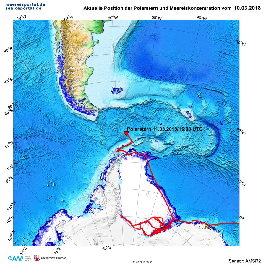
After nearly eight weeks at sea, the expedition, which was led by the oceanographer Dr Michael Schröder, closed on Wednesday, 14 March 2018 in Punta Arenas: ‘Given the late time of year, together with extremely fortuitous ice conditions, in the course of several weeks we were able to cover a research area that would have normally required several separate expeditions. As a result, we were able to not only penetrate to the Antarctic Peninsula in the farthest southwest corner of the Weddell Sea, but also to survey a region off the Filchner Ice Shelf that is covered in ice year-round. Further, on PS111 we achieved something that hadn’t been done since 1986: surveying the entire ice front of Berkner Island (see Figure 1). The last time the Polarstern was here was more than 30 years ago; even before the major iceberg A23A broke off. All of the new data gathered at these sites will substantially improve our understanding of how climate change is affecting this remote region of the Antarctic, and allow us to draw conclusions on how the interplay between the ice shelf, ocean, and sea ice is likely to change in the future,’ Dr Michael Schröder reports. And sea-ice physicist Dr Stefanie Arndt isn’t the only one for whom the expedition was a complete success. The other research groups on board will also be returning to their labs and offices with extensive new datasets, and can hardly wait to start analysing the rarely surveyed areas visited during the expedition.
Contact
Questions?
Contact us via E-Mail or our contact form.
Graphics


