Accordingly, being familiar with the different types of sea ice is important for a range of activities, including navigation at sea, modelling the ice-ocean-atmosphere system, and the remote sensing of other parameters that are connected to sea ice, e.g. the thickness of the snow cover on the sea ice.
In terms of classifying sea ice, we generally differentiate between the following types:
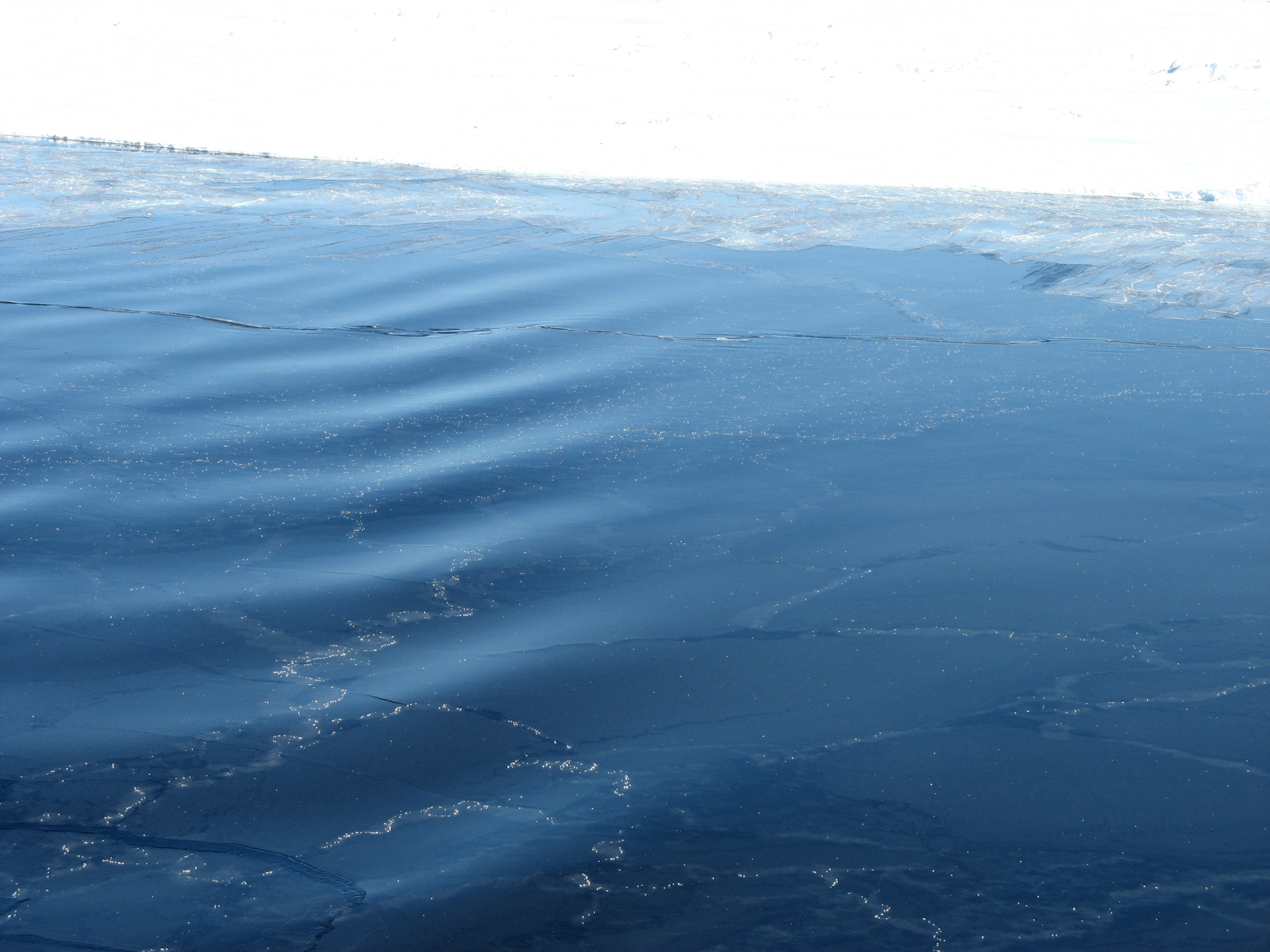
- Young ice (YI): refers to thin (up to 30 cm thick), newly formed ice. This includes a few subtypes, e.g. nilas and pancake ice. Its surface can be smooth or coarse (see Figure 1 and 2).
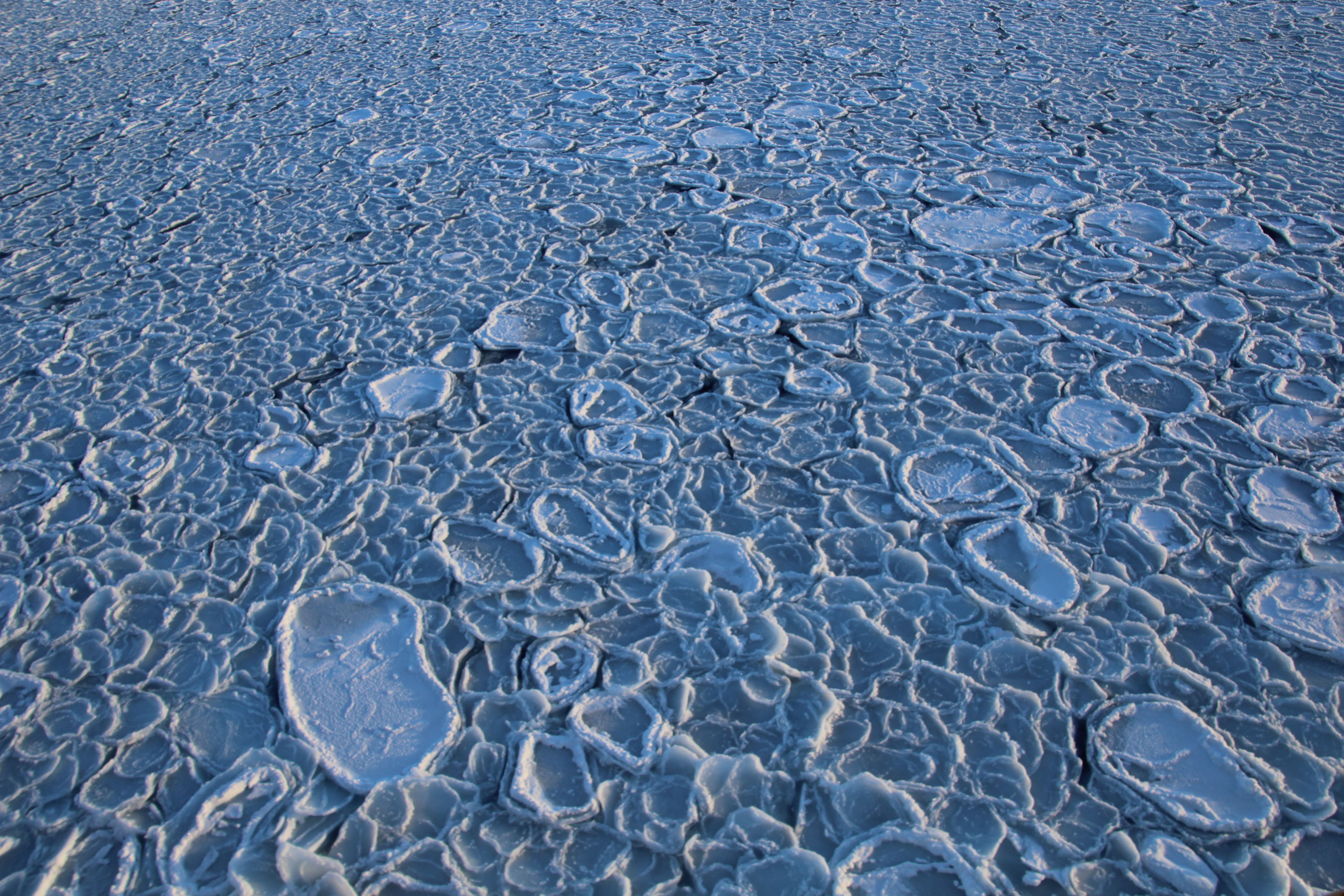
- First-year ice (FYI): this type of sea ice is formed during the cold season (frost season). It has a thickness exceeding 30 cm, and its surface can be smooth, coarse or furrowed (Figure 3).
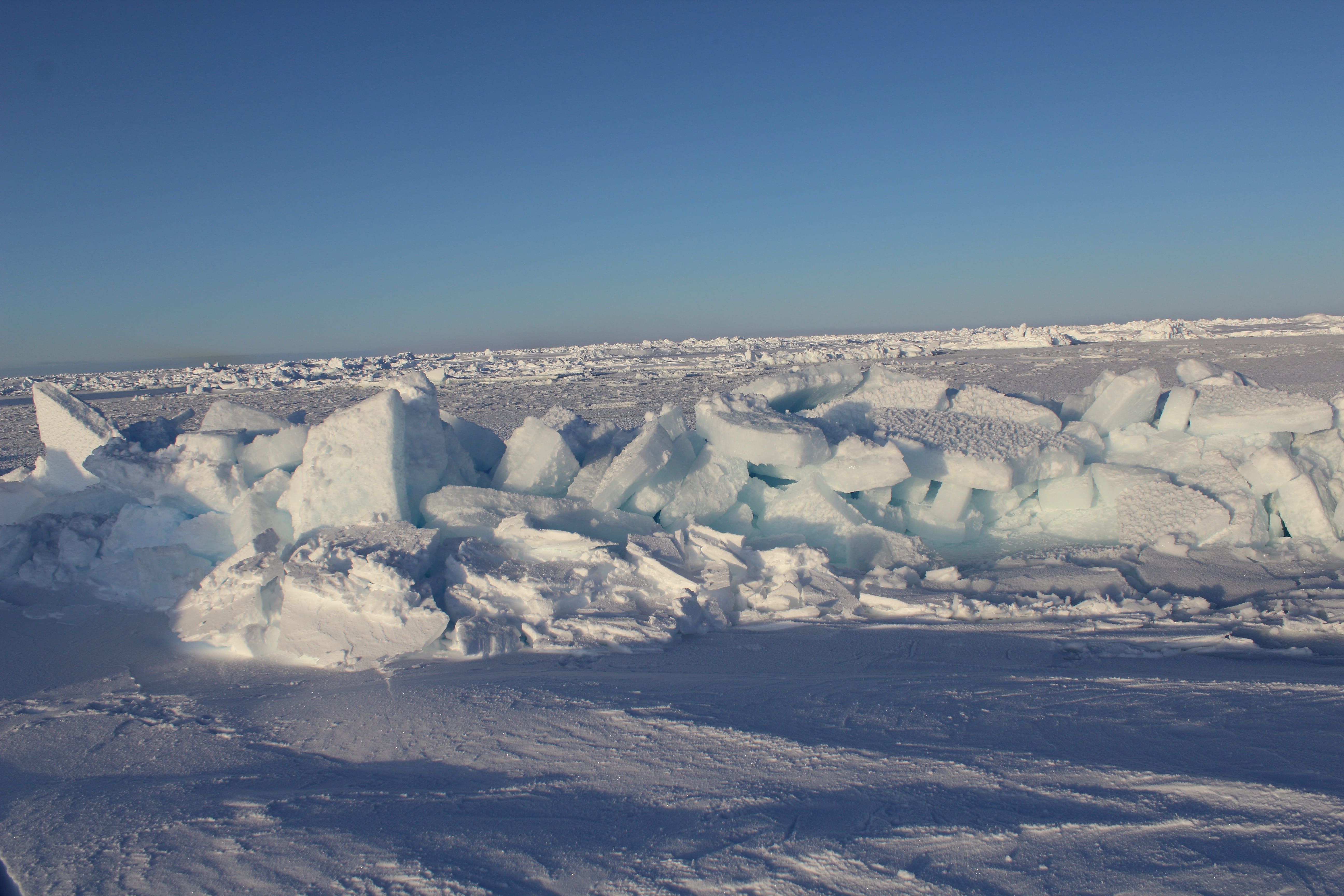
- Multiyear ice (MYI): refers to ice that has survived at least one summer (melting season). It is less salty and in most cases coarser than FYI.
With the recently accelerated loss of multiyear ice in the Arctic, mapping the ice type on a daily basis has taken on a new importance for many applications. Dr Christian Melsheimer, a physicist at the University of Bremen’s Institute of Environmental Physics, was involved in the development and implementation of an algorithm for determining ice types: “Since the 1980s the amount of multiyear ice in the Arctic has virtually been cut in half, and the majority of the loss took place in the past twelve years. It goes without saying that we need to keep a close eye on parameters that change rapidly, and to observe them at regular intervals.” The new product on multiyear ice can be found here.
Whether sea ice, regardless of the type, is smooth or coarse, depends on the local conditions when it was formed. Principally speaking, there are two main routes for ice formation, which are shaped by wind and waves. Sea-ice formation begins when the water’s surface reaches the salinity-dependent freezing point and the net energy balance of the seawater remains negative (i.e., it continues to lose heat). At the outset of this freezing process, ice crystals and plates (‘frazil ice’) form; here, the speed and type of ice-crystal growth greatly depend on the air temperature and wind speed. If the sea and weather are calm, a continuous and smooth crust of ice can form, referred to as nilas. If the conditions are choppy, the previously formed ice slush can form into small floes that, given their unique appearance, are referred to as pancake ice. Both nilas and pancake ice can in turn combine to form a solid sheet of ice, which is initially called young ice and, once it has reached a thickness of 30 centimetres, first-year ice. In other words, it is ice that formed during the winter and is less than one year old. It is only considered to be ‘multiyear ice’ after it has endured the entire melting season in the following summer.
Sea ice grows thicker, the colder the atmosphere is, because the latter draws more heat from the ice and water below it, accelerating the freezing process. However, since sea ice insulates the sea below (i.e. protects it from further cooling) better, the thicker it becomes, sea ice can only reach a thickness of a few metres through cooling alone. But ice floating on the water is also exposed to wind and ocean currents, which constantly move it (sea-ice drift). In the process the sea ice can be deformed, e.g. compacted, piled up or stacked, which can substantially increase its thickness. In fact, what are referred to as pack ice hummocks can be created, with thicknesses of up to ten metres. Multiyear ice is often subject to these dynamic processes, and reaches thicknesses of several metres. Consequently, the formation of sea ice involves a number of different, in some cases simultaneous, thermodynamic (cooling) and dynamic (shifting and deformation) processes.
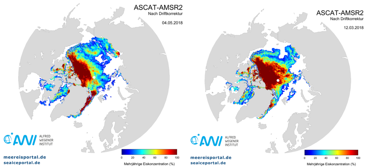
The extent of ocean in the Arctic covered by multiyear sea ice has changed considerably over the past several years. Whereas in the 1980s and 1990s, large expanses of the Arctic Ocean – ca. seven million square kilometres in total – were still covered by multiyear ice, they have now shrunk dramatically, to an area of roughly four million square kilometres. This loss of multiyear ice has been accompanied by a decrease in mean ice thickness, which is currently at approximately two metres, compared to 3.5 metres in 1980. This is connected to a significantly faster loss of ice in the melting region, as well as a reduction in the area covered by ice year-round – a factor that contributes to ‘Arctic amplification’, a term used to describe the fact that the warming in the Arctic is twice as intense as the global average. As Christian Melsheimer explains, “Thanks to the new product, daily maps of the multiyear sea-ice concentration dating back to 2012 are now available. That being said, the data can only be gathered during the frost season (normally from October to April), because once the surface of the ice begins to melt, and therefore liquid water is present, the analytic method used can no longer identify the type of sea ice.”
Figure 4 on the left shows a map of the multiyear sea-ice concentration for 4 May 2018, the most recent dataset currently available; the data for the frost season 2018/2019 is currently being updated and will soon be posted online. As can be clearly seen, the largest area covered by multiyear ice lies to the northwest of Greenland, especially north of the Canadian Arctic Archipelago. This region normally survives the melting period every year, and is accordingly characterised by ice thicknesses of up to ten metres. In comparison to the maximum sea-ice extent in the Arctic on 12 March 2018 (Fig. 4, right), we can see that major expanses of multiyear ice from the Central Arctic have already drifted into the vicinity of the Fram Strait, where they will eventually melt. Multiyear ice from the Canadian Basin drifts with the Beaufort Gyre into the Siberian Sea, where in the course of the summer it, too, will break up and melt. This can be recognised in the lower ice concentrations, together with a larger total area. Generally speaking, the new product from meereisportal.de promises to be a valuable asset for the shipping industry, and for other scientific disciplines that e.g. explore the habitat and ecosystem of the Arctic sea ice.
You can find the new product here.
Contacts
Questions?
Contact us via E-Mail or our contact form.
Graphics


