Not until the end of the month did the sea-ice extent substantially decline, dropping below two standard deviations from the average for the period 1981 – 2010. At the same time, the summer solstice was reached in the Northern Hemisphere, which meant the summer’s influence could be felt the most directly, even in the Arctic. The months that follow will be decisive in terms of how the melting in the Arctic progresses and to what extent the sea ice retreats.
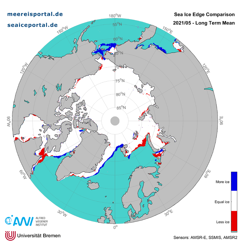
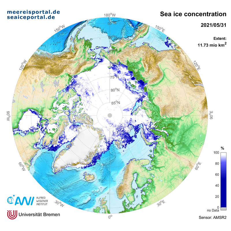
The average sea-ice extent in the Arctic in May, at 12.53 million km², was the ninth-highest in the series of monthly mean values, putting it above the declining long-term trend (Fig. 1). However, by the end of the month the extent had already dropped to 11.73 million km², reflecting the progressive melting underway. There was less sea ice than the long-term average for the years 1981 – 2010 in the northern Barents Sea, which was largely ice-free by the end of the month, and in the northwest Labrador Sea at the Hudson Strait outlet (see Fig. 2). On the Pacific side of the Chukchi Sea and in the eastern Greenland Sea, the amount of ice cover was somewhat above the long-term average. In total, the sea-ice extent was ca. 772,000 km2 below the long-term average, an area roughly the size of Turkey. At the end of the month, patches of open water, also known as polynyas, formed to the east of the Severnaya Zemlya archipelago in the Laptev Sea and north of the New Siberian Islands. Off the coast of Alaska in the southern Beaufort Sea and the eastern Chukchi Sea, the sea ice was also beginning to open (Fig. 3).
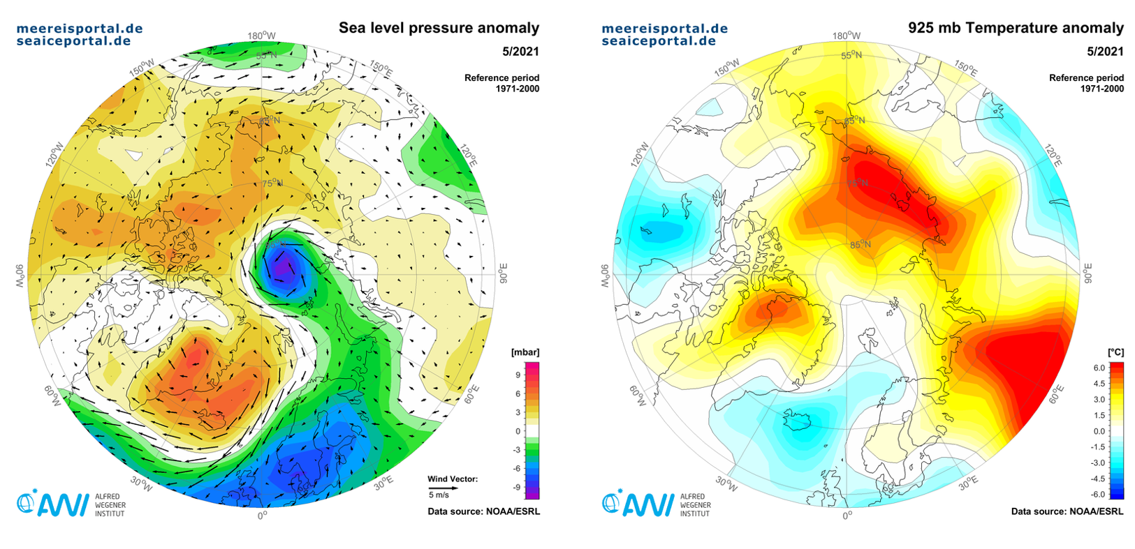
The climatological development in the month of May was characterised by particularly low air pressure at sea level over the Central Arctic and southern Scandinavia, together with high air pressure over eastern Greenland and the Greenland Sea, the combination of which produced an outflow of cold air masses in the North Atlantic, affecting northwest Europe (Fig. 4). May 2021 was the coldest May in Germany since 2010. At the same time, warm air masses made their way across Russia and into the southern Arctic, resulting in air temperatures that were 3° – 5°C above the long-term average along the entire coasts of the Laptev and East Siberian Seas. Generally speaking, in early June the sea-ice development in the Arctic remained at an average level compared to recent years and hovered near the lower edge of two standard deviations from the long-term average. We won’t know until the end of the month how the development of the Arctic sea ice will progress from here. That’s also when the international sea-ice prediction network (SIPN2) will release its first estimate on the September minimum.
Sea-ice development in the Antarctic
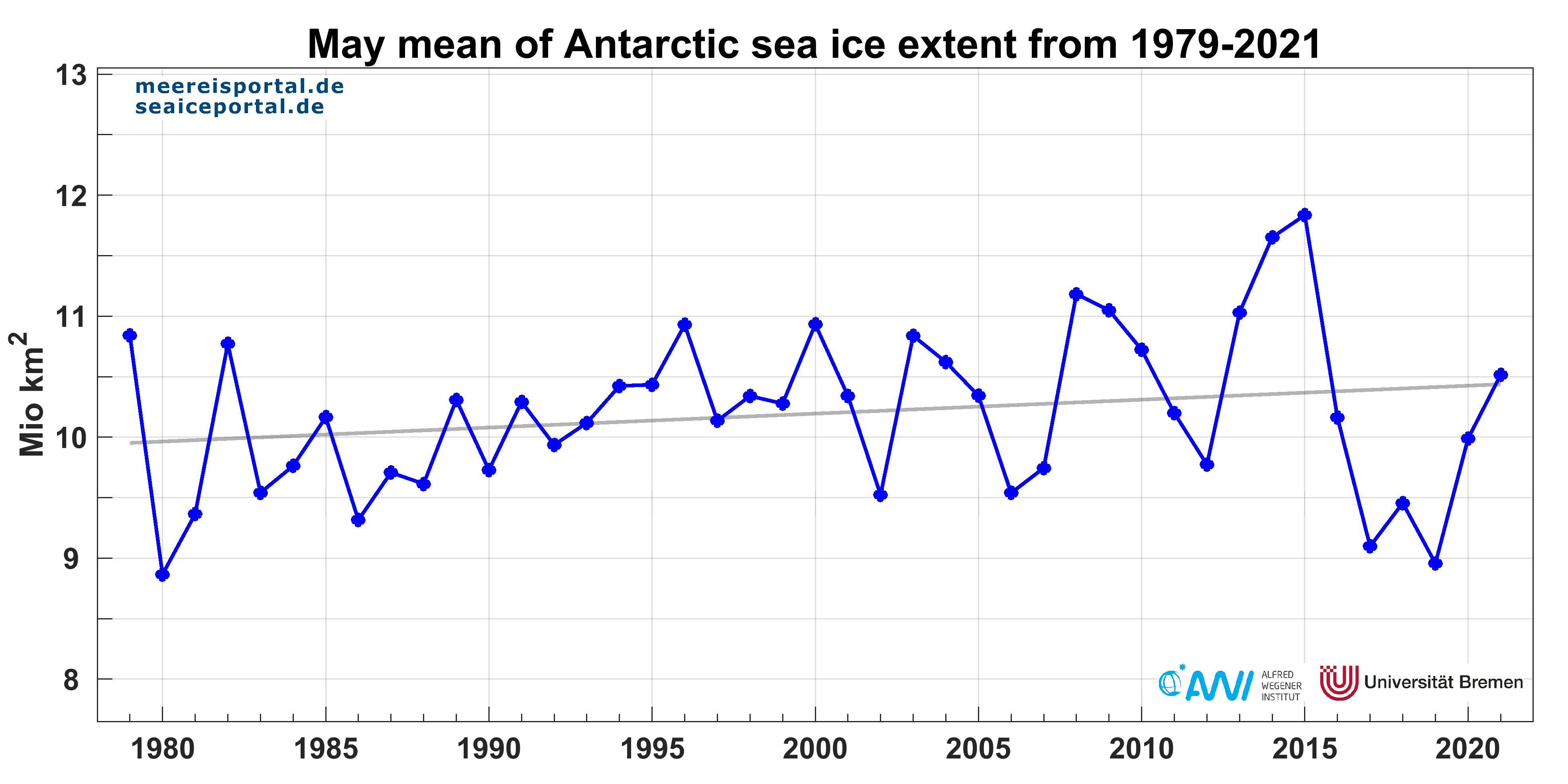
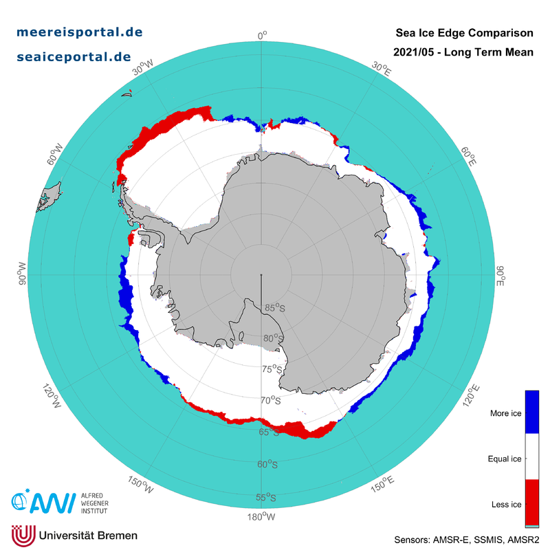
In the Antarctic we’re currently observing similarly average sea-ice development, but in terms of the ice-formation phase (Fig. 5). In May, the sea-ice extent was on average 10.52 million km², the 31st-lowest extent since the beginning of satellite observation in 1979 (Fig. 6). The daily mean growth rate for the sea-ice extent was ca. 100,000 km², an area roughly the size of Iceland. This year, for the first time since 2015, the extent lies above the slightly positive long-term trend of 1.13% growth per decade. While the ice edge has not yet advanced as far north as the long-term average in the northern Weddell Sea and the Ross Sea, all other regions surrounding the Antarctic are characterised by a slightly higher sea-ice extent (Fig. 7). Unfortunately, since a comprehensive assessment of ice thickness in the Antarctic isn’t yet feasible, it’s impossible to say whether the ice volume has also increased, or whether the wind has merely driven the floes apart, leading to more pronounced divergence and therefore a higher sea-ice extent. The Southern Annular Mode (SAM) offers clues in this regard. The SAM is a ring-shaped circulation system of climate variability, which is connected with changes in the intensity and position of the polar jet around the Antarctic and stretches to the middle latitudes of the Southern Hemisphere (e.g. to New Zealand). As such, the SAM produces alternating wind and storm activity between the middle and higher latitudes over the Southern Ocean and the Antarctic. In its positive phase, the SAM is associated with above-normal air pressure in the middle latitudes, which is normally accompanied by relatively light winds and calm weather conditions. In contrast, in the same phase, below-average air pressure is prevalent over the Antarctic and the Southern Ocean, triggering increased wind and storm activity there. The SAM had been in a positive phase since autumn 2020, and only switched to a negative one in the second half of May, such that the mean value for May nevertheless lies at +0.3 (Fig. 8).
Contakt
Questions?
Contact us via E-Mail or our contact form.
Graphics


