In the Arctic, the influence of the sunlight steadily increases until, on 21 June, the Polar Day begins north of the Arctic Circle and the sun never sets for several weeks on end. In the Antarctic, the Polar Night falls and the sun never rises in many areas south of the Antarctic Circle. In the Arctic, the most intensive melting phase begins, while the belt of pack-ice in the Antarctic constantly grows. However, this year we observed a low sea-ice extent for June in the Antarctic which, at a monthly mean of 12.35 million km², even constitutes a record low since the beginning of continuous satellite observation in 1979. In which region can this low sea-ice extent be seen and what are the potential explanations for it?
Monthly sea-ice development in the Antarctic in June 2022
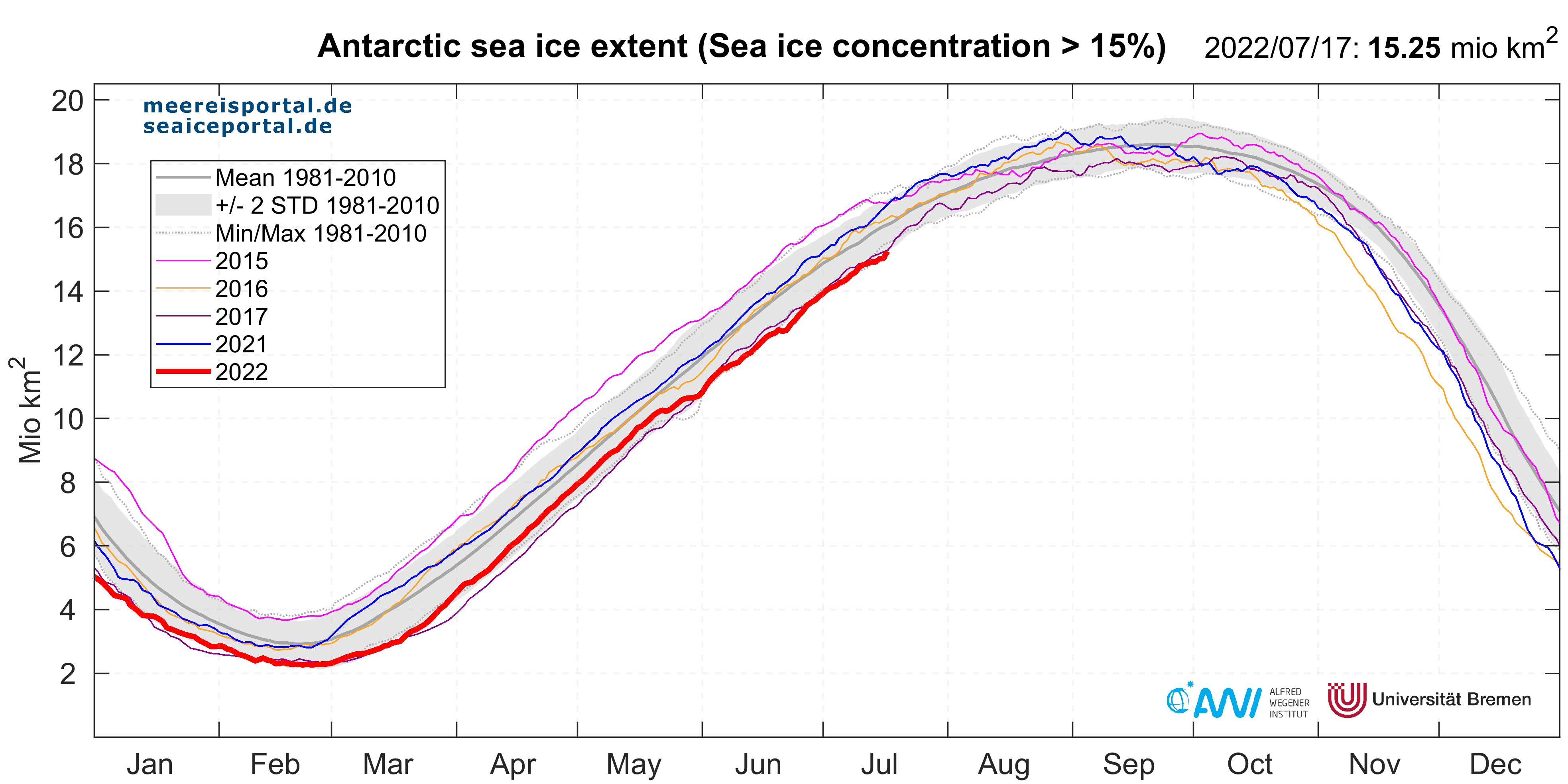
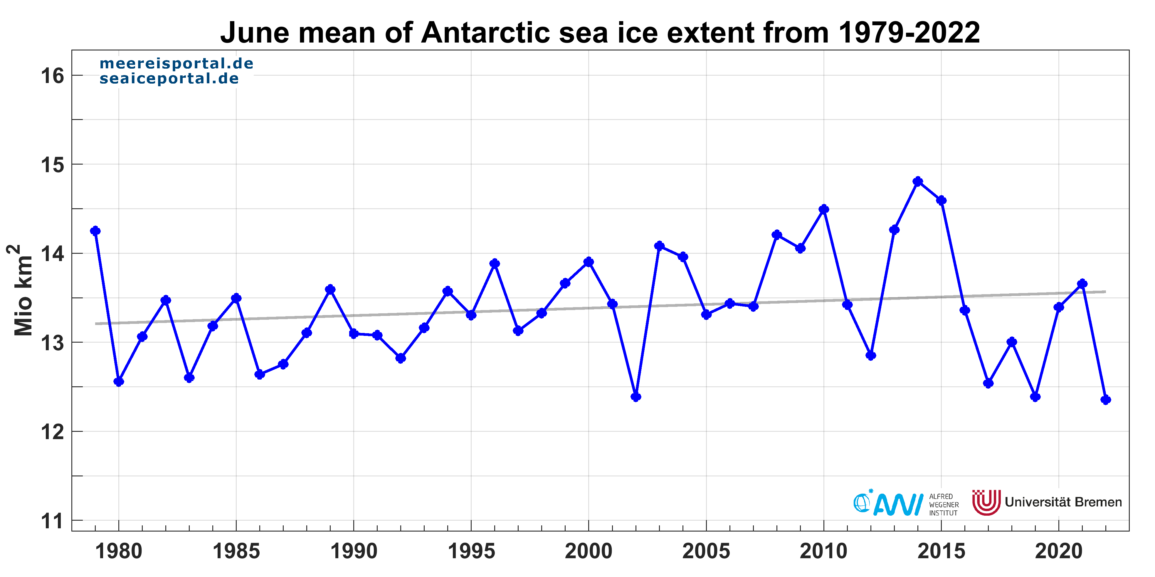
In June 2022, the sea-ice extent increased from 10.82 million km² on 01.06.22 to 13.83 million km² on 30.06.22 (Fig. 1). This represents a mean growth rate of ca. 100,000 km² / day, an area the size of Iceland. Throughout the month, the sea-ice extent development remained near the lower edge of two standard deviations from the long-term average for the years 1981 – 2010, which are considered to be a suitable climatological reference period. On 21.06.22, a particularly low value for the date, at 12.74 million km², was observed. If we consider the development of the mean monthly sea-ice extent in June for the period 1979 – 2022, this year it reached a new low at 12.35 million km², only slightly below the lows recorded in 2002, 2017 and 2019 (Fig. 2). As can be clearly seen, in the past seven years, the monthly mean values have been below the long-term trend (except in 2021). The same can be seen in the other months of the year (s. here). Until 2016, the trend was characterised by a relatively slowly but steadily growing pack-ice belt, at ca. 0.6 % per decade.
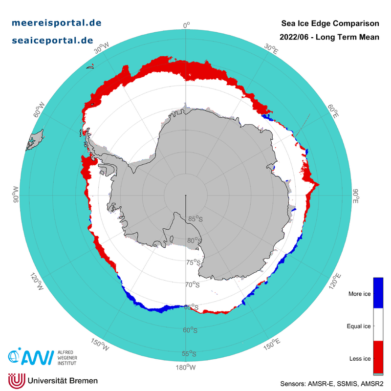
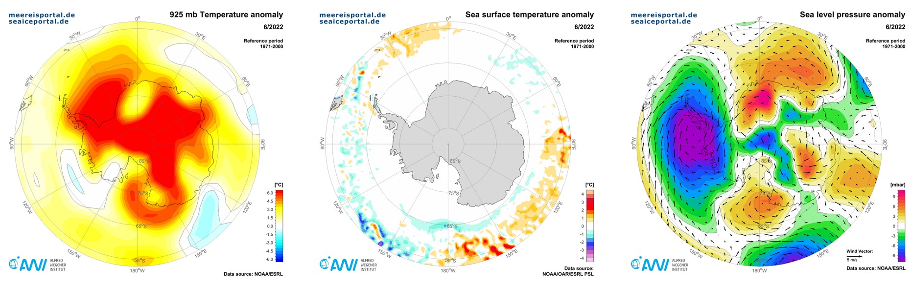
In comparison to the long-term average for the years 2003 – 2014, there is less sea ice, particularly in the northern Weddell Sea to Cosmonauts Sea, and in Bellingshausen and Amundsen Sea (Fig. 3). Overall, the difference to the long-term average is ca. 1 million km². One potential explanation for the unusually low ice growth and the low sea-ice extent for the month could be the unseasonably high air temperatures in the Antarctic at 925 hPa (ca. 760 m), which are significantly above the long-term average virtually across the continent and over the surrounding ocean (Fig. 4). This anomaly covers broad expanses of the Weddell Sea with temperatures up to 6° C above the long-term average for 1971 – 2000. North of the marginal ice zone in the Weddell Sea, surface temperatures up to 1.5°C above the long-term average can be observed, further hindering sea-ice formation. The extensive temperature anomaly over the Weddell Sea and central Antarctica is related to a pronounced low-pressure cell over the Bellingshausen and Amundsen Seas, which transports warm air masses across the Weddell Sea and into central Antarctica. A general change in the weather regime, which would produce more intense cooling and accelerate the growth of the pack ice, is unlikely until the low-pressure cell dissipates.
That being said, according to the National Snow and Ice Data Center (NSIDC), although the wind directions, based on air-pressure patterns, correspond to the temperature differences (cooler winds come from the continent, warmer ones come from the north), they do not generally correspond to the sea-ice pattern: even though cool continental air flows across the Amundsen Sea, the sea-ice extent there is still low. The warm conditions along the coast of Wilkes Land (East Antarctica) did not reduce the sea-ice extent in the region in June.
Monthly sea-ice development in the Arctic
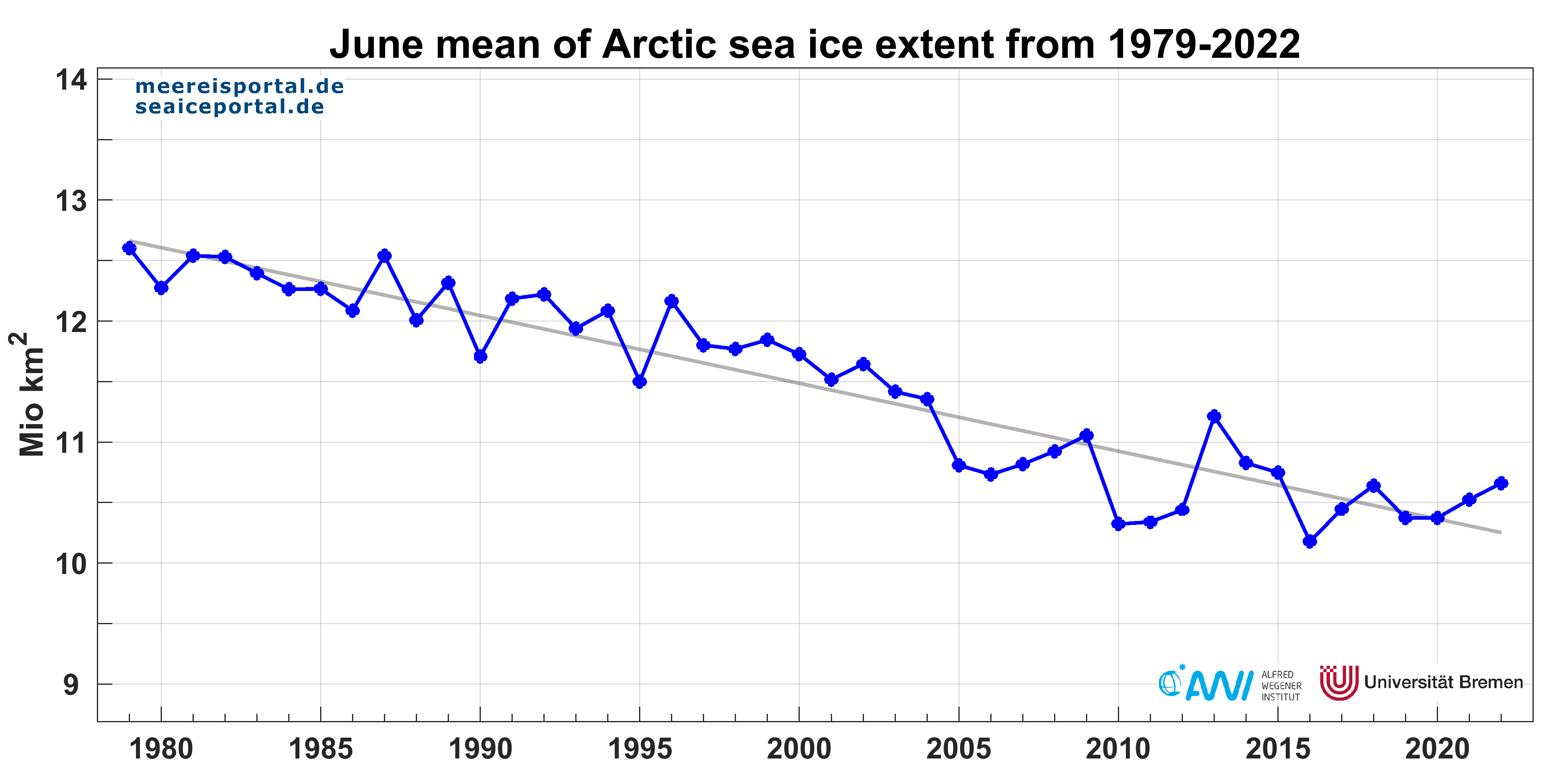
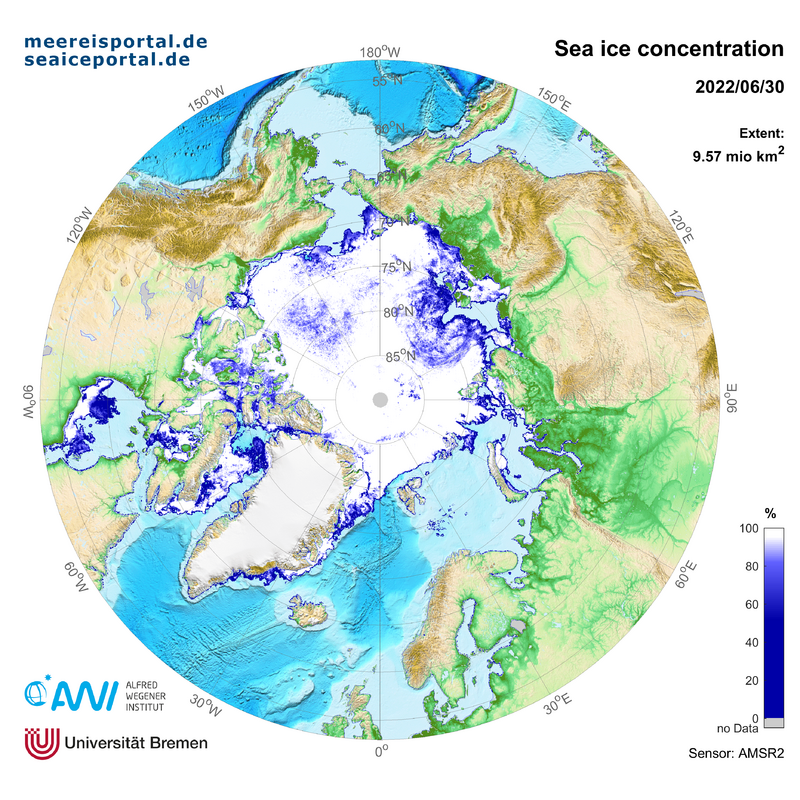
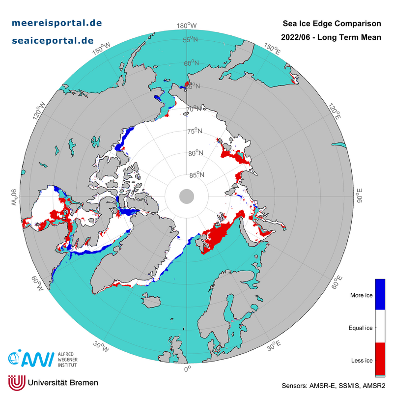
In the Arctic, the sea-ice extent declined steadiyl, by ca. 80,000 km² per day. The mean sea-ice extent for the month was 10.66 million km², putting it in tenth place on the list for the long-term trend (Fig. 5). The ice loss was comparable to last year and remained at the lower edge of two standard deviations from the long-term average for the years 1981 – 2010. Towards the end of the month, lower ice loss in comparison the previous year could be observed. The first open patches appeared in the sea-ice cover of the Siberian Arctic in the Kara and Laptev Seas, in the Chukchi Sea, along the coast of Alaska, and in Baffin Bay (Fig. 6). Especially the Barents Sea has low sea-ice cover for the time of year, while the ice margin is significantly farther north in comparison to the long-term average for the years 2003 – 2014 (Fig. 7).
In June, the first prediction from the Sea Ice Outlook (SIO) was also released. First introduced more than ten years ago, the SIO is a joint effort on the part of the scientific community to compile all available data and observations so as to provide interest groups and the general public with the best possible information on sea-ice development in the Arctic. The predicted median value for the Pan-Arctic sea-ice extent in September is 4.57 million square kilometres with quartiles of 4.34 and 4.90 million square kilometres. This is higher than the value for the September sea-ice extent in the past three years (2019 – 2021) predicted by the SIO at the same time. A summary of the outcomes of the June prediction for the September sea-ice minimum will soon be posted on meereisportal.de.
Contact
Dr. Klaus Grosfeld
Dr. Renate Treffeisen
infoprotect me ?!meereisportalprotect me ?!.de
Graphics
.")


.")


