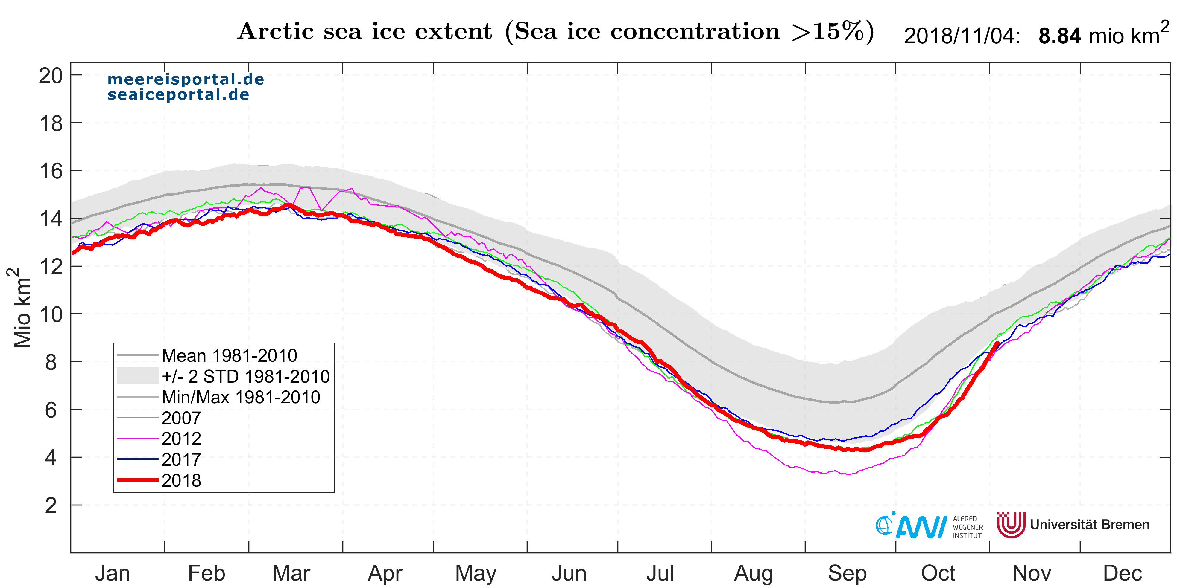
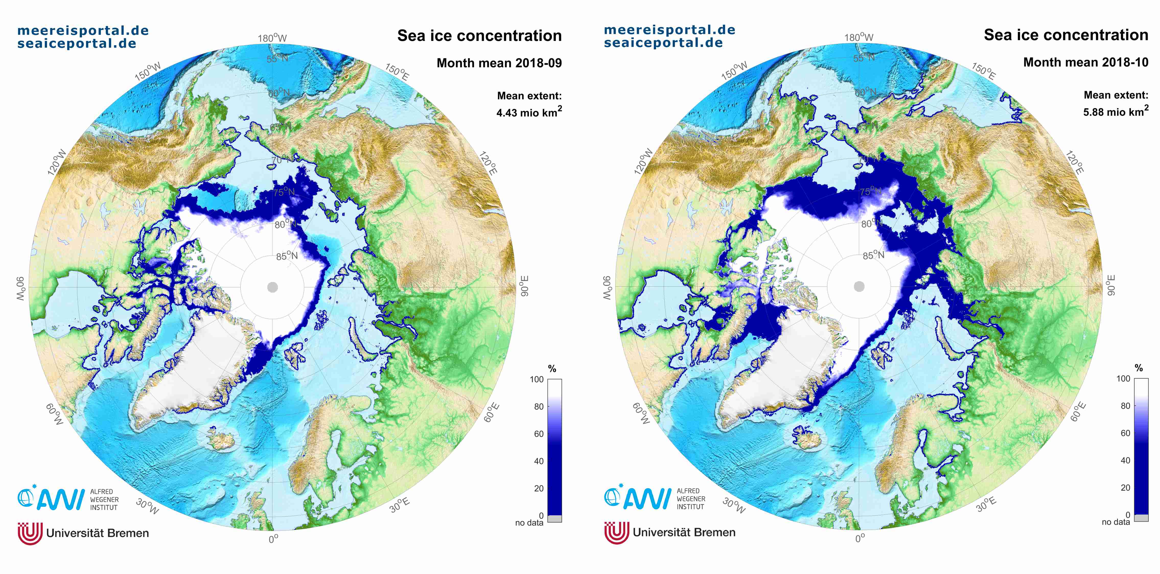
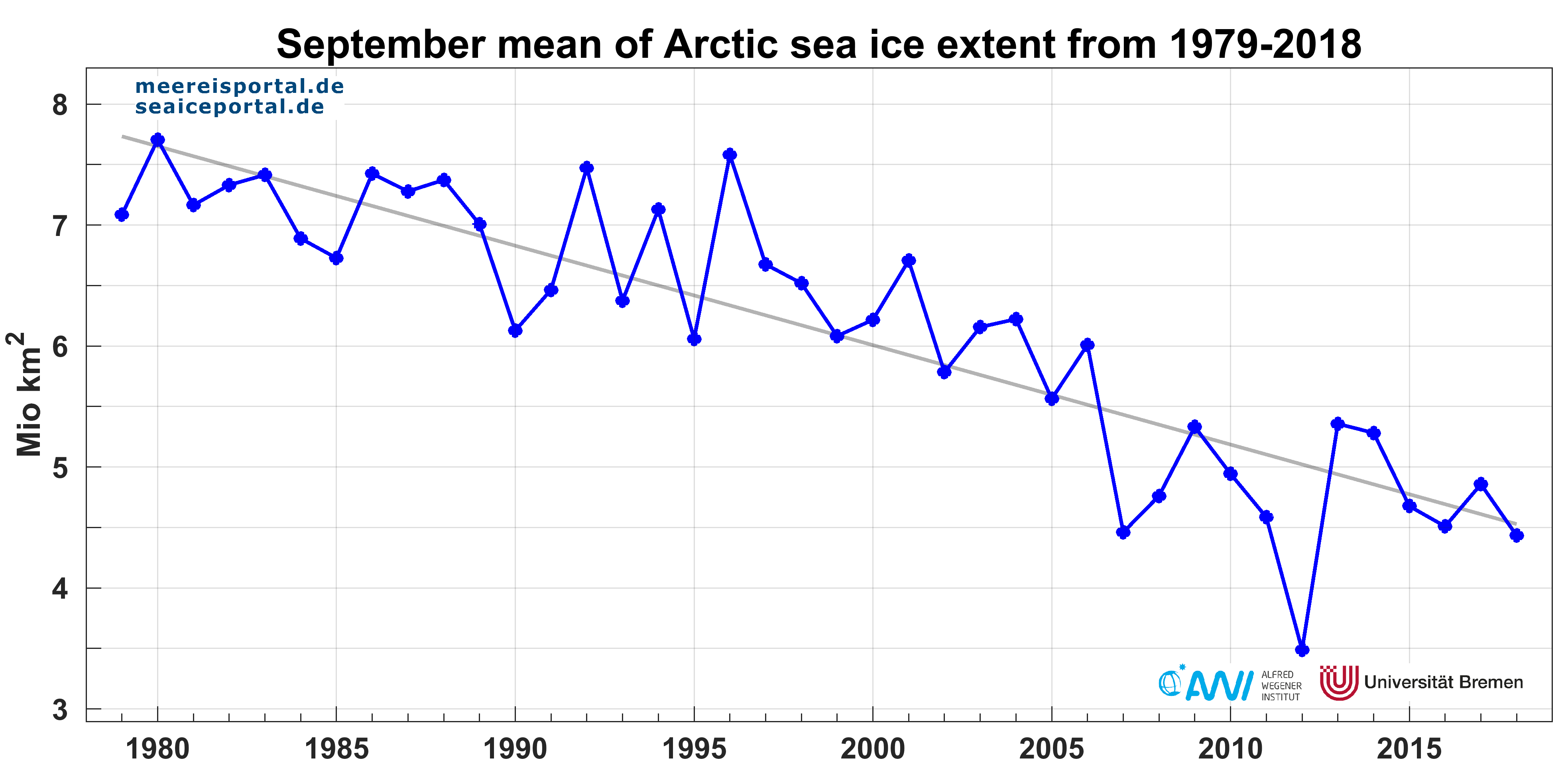
In October, the sea-ice extent in the Arctic was once again below the double standard deviation from the long-term average (Fig. 1). In September 2018 the ice covered an average area of 4.43 million square kilometres (see Figure 2 left); this roughly matches the number for 2007 (4.46 million square kilometres) and is circa 0.94 million square kilometres above the lowest value to date, reached in 2012 (see Figure 3). On 14 September and 21 September 2018, the sea-ice extent reached its absolute minimum of 4.29 million square kilometres. In October the ice covered an area of 5.88 million square kilometres on average, a similarly low value to 2012, the lowest-ever value for October since the beginning of satellite observation (see Figure 2 right).
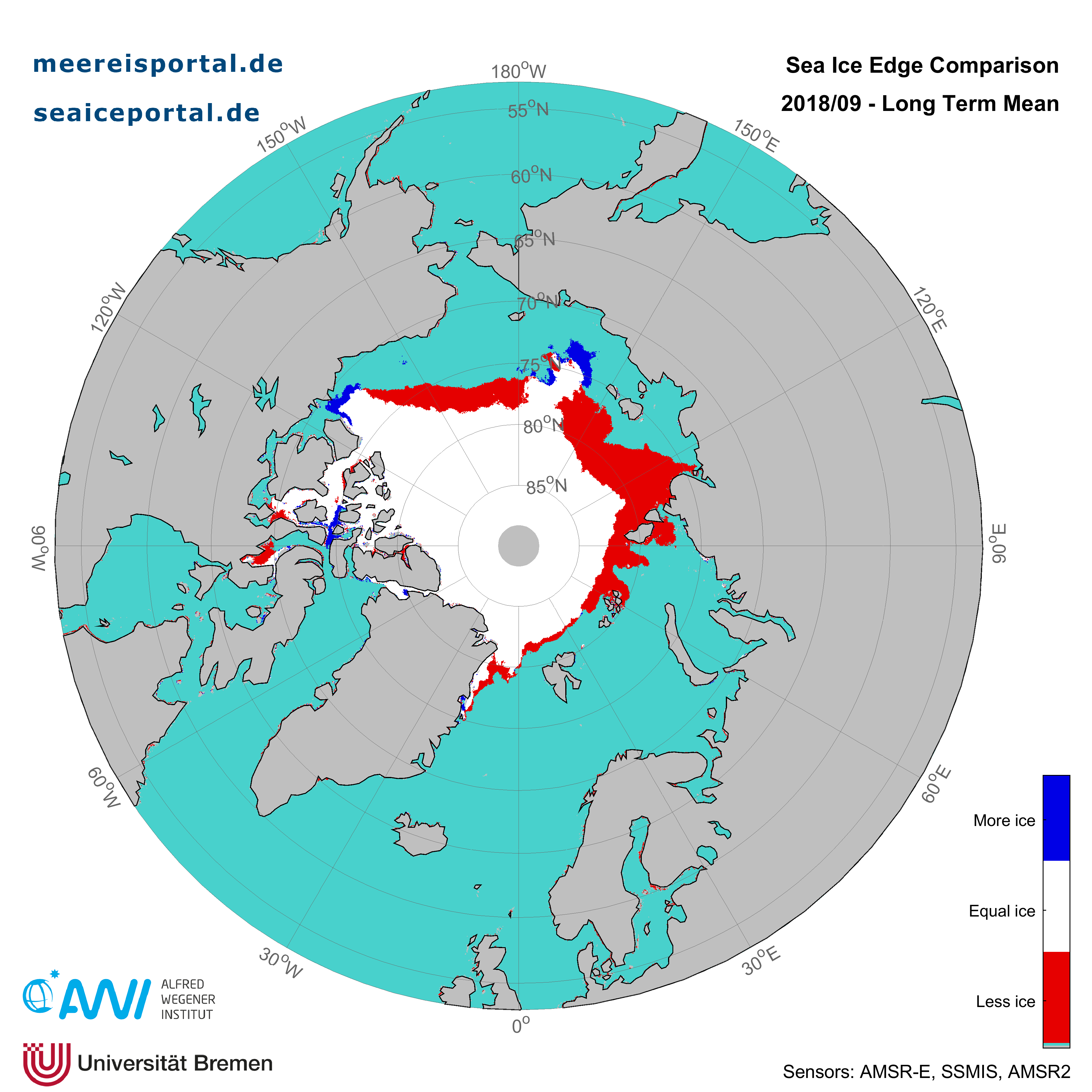
In the first half of September, large quantities of sea ice melted away; major ice loss was observed in the East Siberian Sea, as well as the northern regions of the Laptev Sea and Chukchi Sea (see Figure 4). For a detailed description of the causes, please consult the news entry from 13 September.
“This year, the autumnal rebound in the size of sea-ice cover has been a very slow process; as a result, we’re still at a very low level. Possible causes include the continued warm atmospheric temperatures during the past several weeks, and the residual heat stored in the ocean,” explains Professor Christian Haas, head of the sea-ice physics section at the AWI. “That being said, the ice will continue to grow, and thin ice grows more quickly. Accordingly, the current situation isn’t likely to have much effect on the remainder of the winter.”
Current atmospheric temperature data from buoys in the Central Arctic
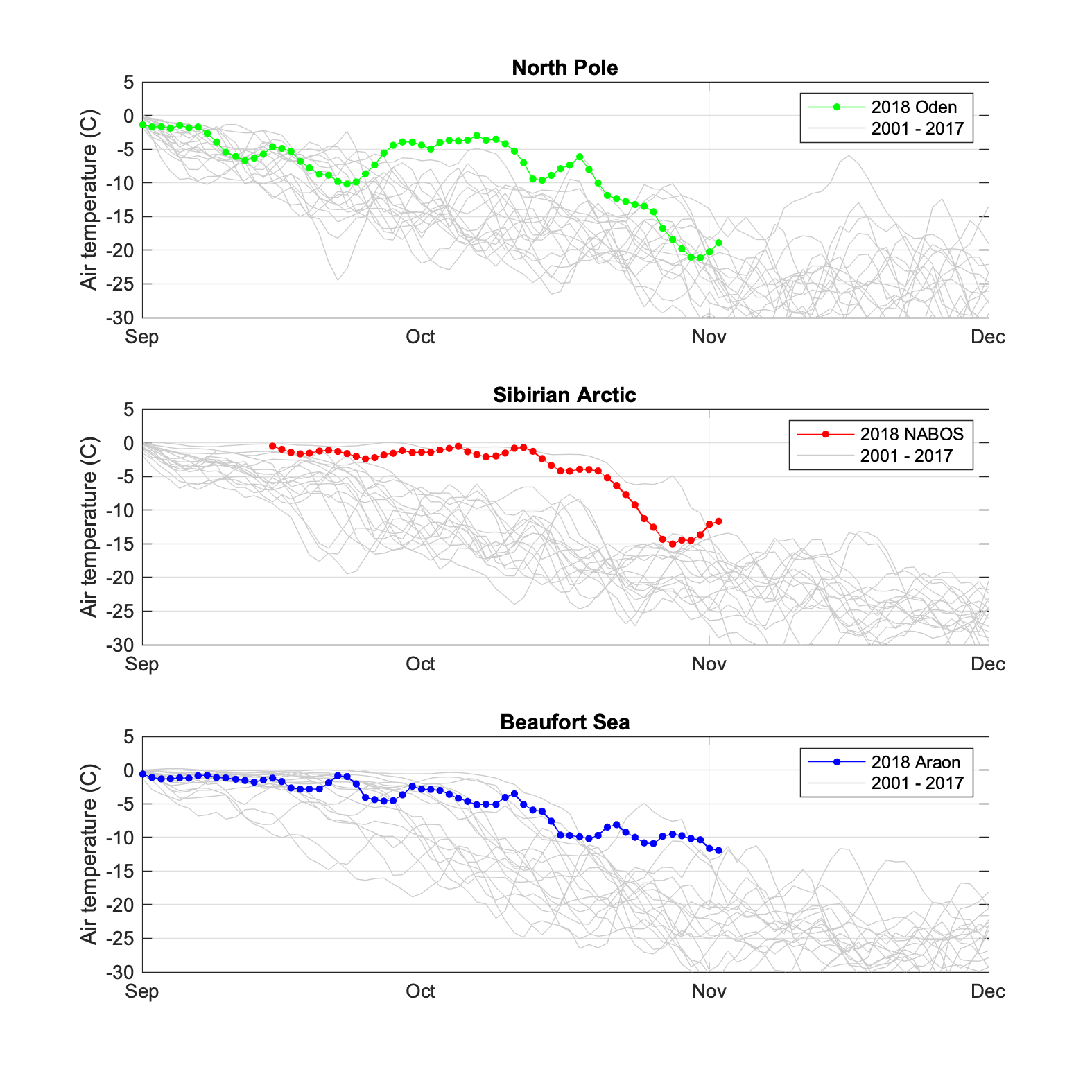
Currently, sixteen of our snow buoys transmit atmospheric-temperature data on an hourly basis to international weather forecasting systems (via the Global Telecommunication System, GTS); this data is also available on meereisportal.de. The AWI deployed the buoys on ice floes in the course of three icebreaker missions. Eight were installed in the northern Laptev Sea in the context of NABOS (the Nansen and Amundsen Basins Observational System), six were set up near the North Pole by the Swedish research vessel ODEN, and two were launched in the Beaufort Sea by the South Korean icebreaker ARAON (see Figure 5). The atmospheric-temperature data (see Figure 6) shows an especially warm Arctic, even in comparison to the past few years. Throughout October, atmospheric temperatures remained in the uppermost range compared to the past 17 years. It was especially warm in the northern Laptev Sea, but near the North Pole atmospheric temperatures only showed a significant decline in the last week of October, much later than in previous years. And in the Beaufort Sea, extremely high temperatures continued to be measured, even at the end of the month.
“It’s unique that we have such a good basis of data for measuring atmospheric temperature (and snow thickness) this autumn, since, with the sixteen buoys now in place, we were able to deploy an unprecedented network of autonomous stations. Further buoys, which measure additional parameters of the atmosphere, sea ice and ocean, are also part of the network. This is all thanks to outstanding and intensive international collaboration; without it, we could never have installed this number of buoy systems,” says Marcel Nicolaus, a sea-ice physicist at the Alfred Wegener Institute.
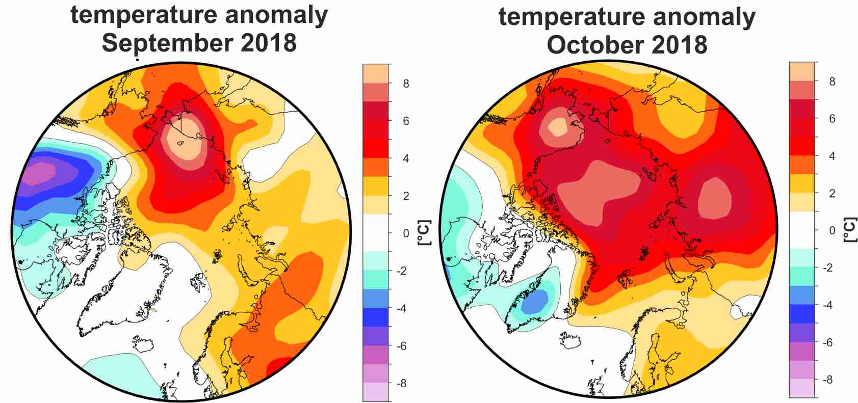
In October, atmospheric temperatures in the troposphere (925 hPa level; circa 765 m above the surface of the ice) were up to 7 degrees higher than the long-term average over the central Arctic Ocean, though they were below the long-term average in Greenland (see Figure 7). As a result, ice growth was slow in these regions.
Ice thickness
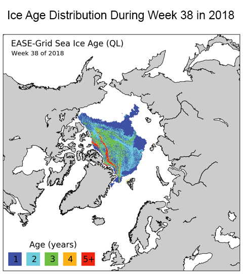
In the course of the winter, seasonal ice can grow to thicknesses of between 1.5 and 2 metres. If it survives the summer, the ridging and rafting of ice that take place in the following winter can boost its thickness to 3 metres and more. Multiyear ice has better chances of enduring through the summer. In the spring and summer months, multiyear ice was transported to the Beaufort Sea from the northwest as part of the drift produced by the Beaufort Gyre, which, viewed from above, spins clockwise off the northern coasts of Canada and Alaska, in the vicinity of the Beaufort Sea. In contrast, the ice tongue in the East Siberian Sea was chiefly composed of seasonal ice (Figure 8a) (Source: NSIDC).
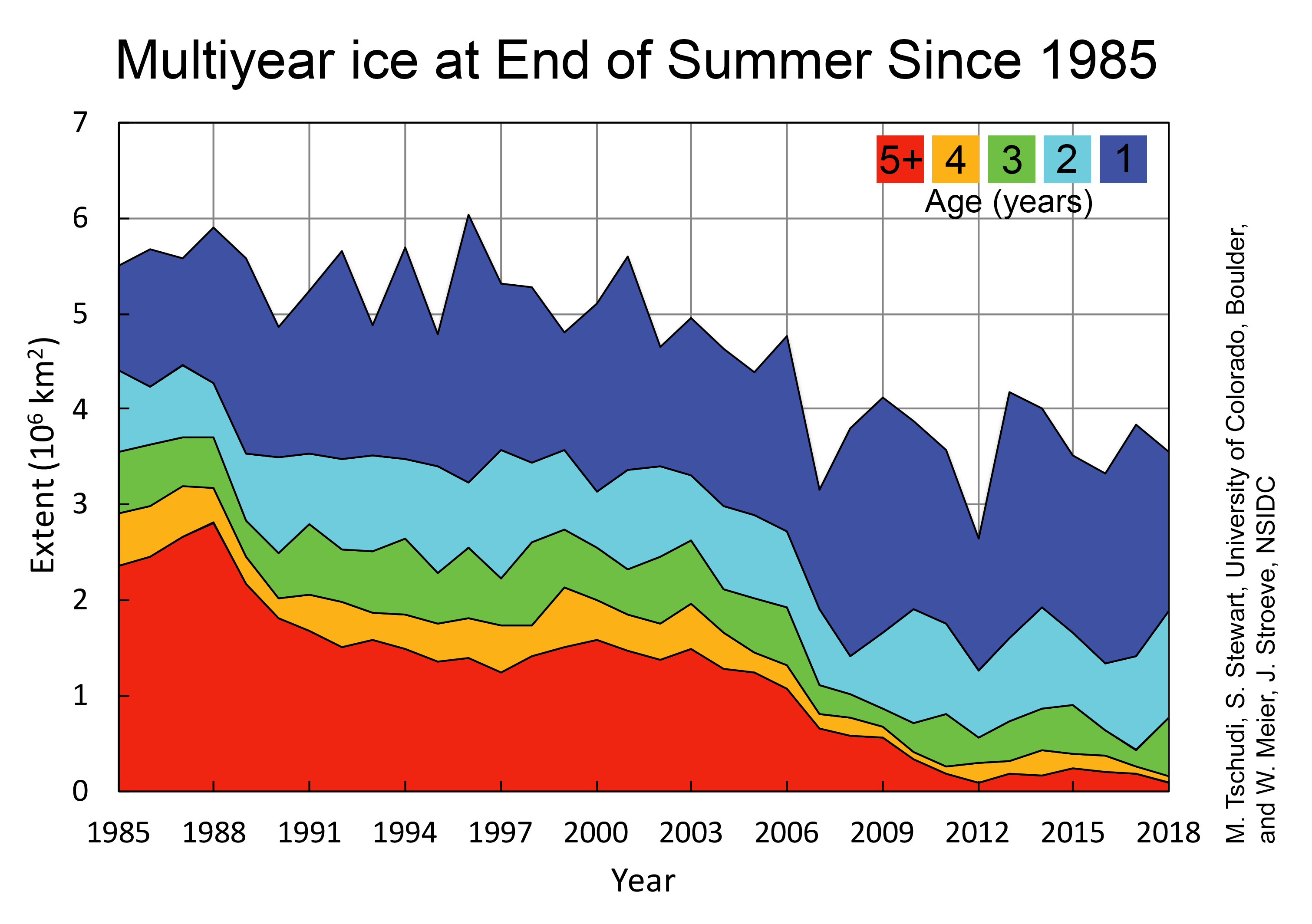
In brief, the amount of late-summer multiyear ice has declined substantially since the 1980s and 1990s. Today the Arctic Ocean is covered by a maximum of 2 million square kilometres of multiyear ice. The ‘oldest’ sea ice, i.e., ice that had already survived for at least four melting periods, used to cover roughly 1.5 million square kilometres (see Figure 8b). According to NSIDC data, during the minimum in September 2018 the extent of old ice was a mere 0.094 million square kilometres (Source: NSIDC).
Contacts
- Prof Dr Christian Haas (AWI)
- Dr Marcel Nicolaus (AWI)
Questions?
Contact us via E-Mail or our contact form.
Graphics


