Active microwave sensors (radar)
In addition to those using passive sensors, there are satellites that actively emit microwaves toward the Earth in a frequency range of ca. 1 to 20 GHz. These are reflected back from the surface (also referred to as backscatter) and recorded by the sensor.
This is known as an “active microwave sensor” or radar (radar itself stands for RAdio Detection And Ranging). As such, radar systems are used for locating (detection) and measuring distances (ranging) alike.
The sensor emits microwaves toward the Earth’s surface and measures the reflected radiation. Just like in passive systems, the physical characteristics of objects on the Earth’s surface determine the amount and type of returning microwave radiation received by the sensor.
The intensity of backscattering and time delay between emitting and receiving the (reflected) signal are used to determine the distance to the object. In addition, the backscattering intensity offers insights into the object’s properties. Three types of active microwave sensors are used to measure sea ice: radar altimeters (e.g. Cryosat-2), scatterometers (e.g. QuikSCAT), and radar synthetic aperture radars (SAR, e.g. Sentinel-1A/B).
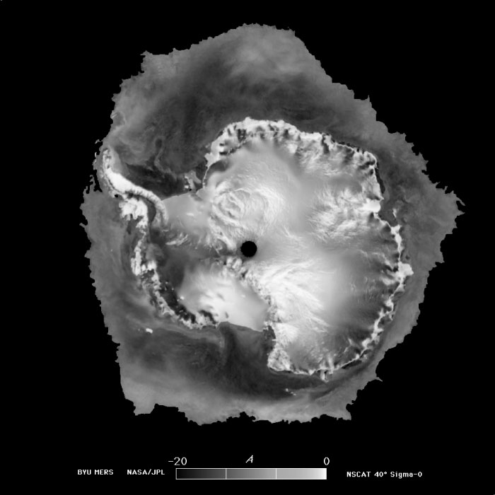
An imaging radar system produces images very similar to camera photographs. However, the images are based on radar waves – i.e., microwave radiation – and not on visible light. In this regard, sea ice can easily be distinguished from the ocean, because it reflects back far more of the emitted radar energy than the ocean’s surface.
Since radar waves have a much higher wavelength than light, the spatial resolution of radars, which is proportional to the wavelength, is actually much poorer. In addition, the spatial resolution is inverse proportional to the aperture (the size of the opening in an instrument that uses visible light and infrared) and to the size of the antenna in microwave instruments like radar. Accordingly, to achieve similar resolution to that of visible light, a radar would have to have an infeasibly large antenna (measuring kilometres long). Since antennas of that size can’t be fitted on satellites, SAR (Synthetic Aperture Radar) is used instead. In this approach, the size of antenna needed is “simulated” by the movements of the satellite – which is only equipped with a small antenna – during flight.
The smaller an antenna is, the broader the beam that it emits. A typical radar satellite antenna (1 to 2 m diameter) scans a ca. 50-km-wide area on the Earth. Since the satellite is in motion (at a speed of ca. 7 km / s), a given point on the Earth’s surface is only touched by the pulsed radar beam for a few seconds. The radar instrument then combines all the backscattered signals from these points on the Earth’s surface in those seconds, covering a distance of ca. 50 km as it does (the same distance as the diameter of the scanned area on the surface). In this way, the system simulates a 50-km antenna, producing a “synthetic” antenna that is roughly 1,000 times the size of its actual, physical antenna. Consequently, the spatial resolution is roughly 1,000 times better and lies in the range of several metres.
Since 1978, when the first one was used on NASA’s Seasat satellite, SAR systems have become an enormously valuable tool for sea-ice observation.
In contrast to altimeters and scatterometers, which can detect the structure of and height differences on a given surface, SAR produces spatially resolved images. SAR is most often used as side-view radar, which displays a strip of the Earth’s surface parallel to the direction of flight. The resulting images are similar to those from cameras and scanners. However, SAR instruments have a key advantage: they can penetrate clouds and be used at night. Moreover, in comparison to microwave radiometers, their spatial resolution is considerably better.
The European Space Agency (ESA) Sentinel-1 mission is perhaps the best-known ongoing SAR mission. The interpretation of observational data from SAR instruments remains challenging, even though the two-dimensional, photograph-like format is very helpful. Generally speaking, thicker multiyear ice can easily be distinguished from young first-year ice because more air pockets are trapped in multiyear ice after brine seepage. These air pockets increase signal scattering and depolarisation. This unique aspect makes SAR extremely helpful in terms of differentiating between thick and thin ice. SAR instruments can even identify small leads in sea ice. And thanks to their fine resolution, the results can be applied to ship’s routes or be used at operational centres.
This type of sensor, known as a scatterometer, measures the strength of the backscattered radar signal, and does so for various azimuths in relation to the direction of flight – typically tilted forward, to the side, and tilted backward. Scatterometers can provide daily updated data on the sea ice – by day, by night, and even with heavy cloud cover – with roughly the same accuracy as passive microwave sensors (see below).
To do so, scatterometers above all use surface roughness. One example: ASCAT (Advanced SCATterometer QuikSCAT). The ASCAT instrument measures radar backscatter along two ca. 500-km-wide swathes to the right and left of the satellite’s flyover track at ca. 25 km spatial resolution. The radar backscatter from the ocean’s surface is a function of its surface roughness, which is itself a function of near-surface windspeed. A scatterometer uses microwaves in a frequency range from ca. 1 to 20 GHz and offers a daily, worldwide view on the wind field over the oceans and on the sea ice. ASCAT is the successor to QuikSCAT. In the planning phase, one major priority was to continue the time series of surface wind vectors from QuikSCAT data as seamlessly as possible; the QuikSCAT wind dataset ended in 2009.
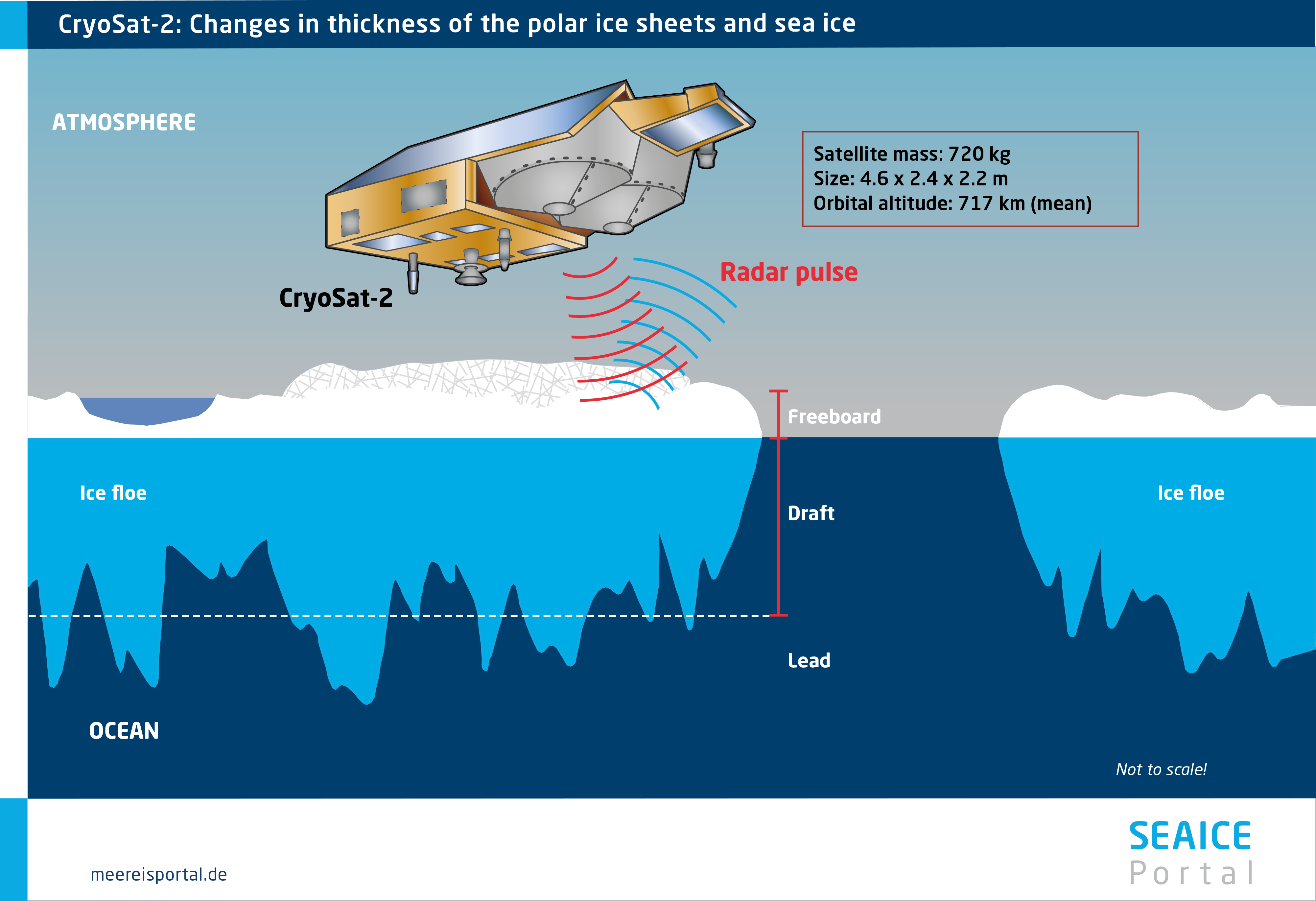
Radar altimeters use high-precision radar to measure the distance between a given satellite and the Earth’s surface. These readings can be used to determine e.g. sea-level rise and changes in continental ice sheets. This is done by measuring changes in a given surface’s vertical profile. The same method can be used to determine the thickness of floating sea ice.
To do so, the floe’s “freeboard” must be determined: the height of the ice above the water’s surface. Freeboard is measured on the basis of distance measurements taken over the sea-ice surface and over the water in leads between floes. The measurements taken over leads can be used to derive the precise sea level in ice-covered regions.
In turn, the freeboard can be used to derive sea-ice thickness, though further information like the thickness of snow cover in winter and the ice’s density is also needed in order to do so. These two parameters determine the ratio of sea-ice freeboard to thickness.
On 8 April 2010, the European Space Agency (ESA) satellite CryoSat-2, specially designed to measure and monitor polar ice, was successfully launched. With an orbit that nearly reaches to the poles (coming nearest to them at 88 degrees N and S), CryoSat-2’s coverage is closer to them than any previous ESA satellite, like Envisat (ca. 81.5 degrees N and S). Orbiting at an altitude of 720 kilometres, it is the first satellite to offer worldwide ice-thickness data on a regular basis.
The radar instrument on board CryoSat-2 is called SIRAL (Synthetic Aperture Interferometric Radar Altimeter), which, just like SAR instruments, employs a synthetic aperture (simulated large antenna), allowing it to offer substantially higher spatial resolution than conventional radar altimeters. In concrete terms, this means that information from nearby and overlapping radar echoes are used to achieve a resolution that is smaller than the area covered by a single echo. CryoSat-2’s horizontal resolution is roughly 300 metres, compared to several kilometres (the resolution of the radar altimeters used on Envisat and the ERS (European Remote Sensing Satellite) satellites). High spatial resolution is indispensable for accurately measuring sea-ice thickness.
CryoSat-2 was a trailblazer for measuring sea-ice thickness. However, since first being launched, it has been joined by other radar altimeters for monitoring the ice-covered oceans. In particular, the European satellites Sentinel-3 A and B use a very similar radar altimeter and offer an increasingly dense observational network.
The greatest limitation on CryoSat-2 ice-thickness data is that important parameters for converting freeboard into ice thickness, like the thickness of the snow cover, cannot be measured directly. Currently, this information has to be acquired from other sources. The next generation of radar altimeters are meant to change that. The Copernicus Polar Ice and Snow Topography Altimetry (CRISTAL) satellite mission, slated for 2027, will include a radar altimeter that can simultaneously measure freeboard and snow thickness. Compared to CryoSat-2, the spatial resolution will be even better, which means we can expect significantly more accurate ice-thickness information from CRISTAL.